Buildings
Disclaimer
Overview
Buildings is a digital dataset representing buildings across Australia. The Buildings dataset has relationships with the G-NAF, Cadastre, Property and Administrative Boundaries products produced by Geoscape Australia.
Data quality and potential capture timelines will vary across Australia based on three categories. Each category has been developed based on several factors defined by the population distribution (categorised based on population size), industrial/commercial activities, the probability of natural events (e.g. flooding) and the image source.
Urban (satellite source) - areas with a population greater than 200, or with significant industrial/commercial activity in a visual assessment, digitised from satellite imagery
Urban (aerial source) - areas with a population greater than 200, or with significant industrial/commercial activity in a visual assessment, digitised from aerial imagery
Rural – all other areas
Geoscape welcomes your feedback on the Buildings product. We also publish regular product development updates on our website ( www.geoscape.com.au ).
Release Summary
This product was released to customers on 20 December 2023 with data extracted on 15 December 2023.
This release is a full national data population for Version 3.2 of the Buildings product, described by the Buildings Product Guide v3.2.
A new attribute named ‘roof_slope’ has been added to the buildings table. This attribute represents the maximum angle of slope in degrees of the building roof structure, rounded to standardised class values.
Any issues that have been identified for this release are described in the Issues section.
This release includes updates for the areas listed in the table below.
State |
Location [1] |
Urban Area (km2) |
|---|---|---|
NSW |
Broken Hill City Council |
50 |
NSW |
Federation Council |
20 |
NSW |
Goulburn Mulwaree Council |
59 |
NSW |
Muswellbrook Shire Council |
20 |
NSW |
Singleton Council |
48 |
NSW |
Unincorporated - Far West Area |
1 |
QLD |
Noosa Shire |
211 |
QLD |
Sunshine Coast Regional |
906 |
SA |
Port Augusta City Council |
75 |
TAS |
Brighton Council |
83 |
TAS |
Burnie City Council |
37 |
TAS |
Central Coast Council |
93 |
TAS |
Clarence City Council |
252 |
TAS |
Derwent Valley Council |
3 |
TAS |
Devonport City Council |
61 |
TAS |
Glenorchy City Council |
47 |
TAS |
Hobart City Council |
39 |
TAS |
Kingborough Council |
93 |
TAS |
Latrobe Council |
49 |
TAS |
Launceston City Council |
106 |
TAS |
Meander Valley Council |
20 |
TAS |
Northern Midlands Council |
63 |
TAS |
Sorell Council |
94 |
TAS |
Southern Midlands Council |
3 |
TAS |
Waratah-Wynyard Council |
29 |
TAS |
West Tamar Council |
52 |
VIC |
Banyule City |
15 |
VIC |
Bayside City |
37 |
VIC |
Boroondara City |
30 |
VIC |
Brimbank City |
69 |
VIC |
Casey City |
11 |
VIC |
Darebin City |
21 |
VIC |
Frankston City |
65 |
VIC |
Glen Eira City |
31 |
VIC |
Glenelg Shire |
40 |
VIC |
Hobsons Bay City |
63 |
VIC |
Indigo Shire |
14 |
VIC |
Kingston City |
8 |
VIC |
Latrobe City |
27 |
VIC |
Maribyrnong City |
31 |
VIC |
Melbourne City |
38 |
VIC |
Melton City |
21 |
VIC |
Merri-Bek City |
19 |
VIC |
Moonee Valley City |
30 |
VIC |
Mornington Peninsula Shire |
299 |
VIC |
Port Phillip City |
21 |
VIC |
Stonnington City |
22 |
VIC |
Wyndham City |
70 |
VIC |
Yarra City |
20 |
WA |
City of Albany |
111 |
WA |
City of Kalgoorlie-Boulder |
48 |
WA |
Shire of Esperance |
35 |
Total |
3710 |
Spatial files of the updated areas are available upon request via support@geoscape.com.au.
Change Notifications
New roof_slope attribute
A new roof slope attribute has been added to the Buildings product. This attribute (roof_slope) represents the maximum angle of slope of the building roof structure in degrees, rounded to standardised class values. The data type is number (4,2), with the ESRI Shapefile 10-character alias being ROOF_SLOPE.
The roof slope attribute is provided where possible for buildings captured from aerial imagery, all other records have a <NULL> value.
The addition of this new attribute has resulted in a minor increment to the Buildings product version, making it 3.2.
File Geodatabase (GDB) format - Removal of relationship classes
The File Geodatabase format will no longer support relationship classes between records included in the layers within the GDB. This does not mean any change to the representation of the layers within the file.
ESRI Shapefile width increase
Commencing with the February 2024 release, the width of numeric fields within Esri Shapefiles will increase by one. This is due to a bug fix in our packaging application. This change only impacts Shapefile metadata, the values and precision remain unchanged.
TAS Building Heights
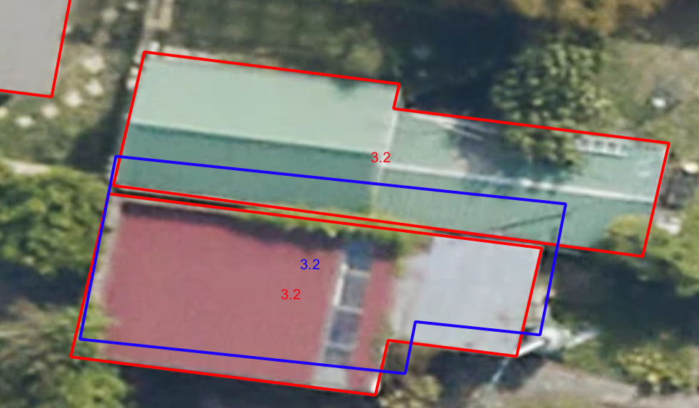
The capture data for Tasmania used in the December 2023 release was undertaken using high-resolution aerial imagery, however, it did not include roof or eave height information. These aerial-capture buildings have been assigned heights from previously existing satellite-captured buildings using spatial matching rules. We have been able to assign building heights to 76.5% of buildings using this methodology. In the image below, the heights from satellite-captured buildings (blue) have been assigned to the new aerial-captured buildings (red) through these rules.
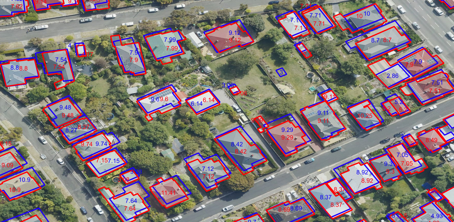
© Aerometrex Ltd Aerial Imagery [Aerometrex, 2023]
The remaining buildings have null height information and are primarily small sheds (black) that were not captured in the original satellite data.
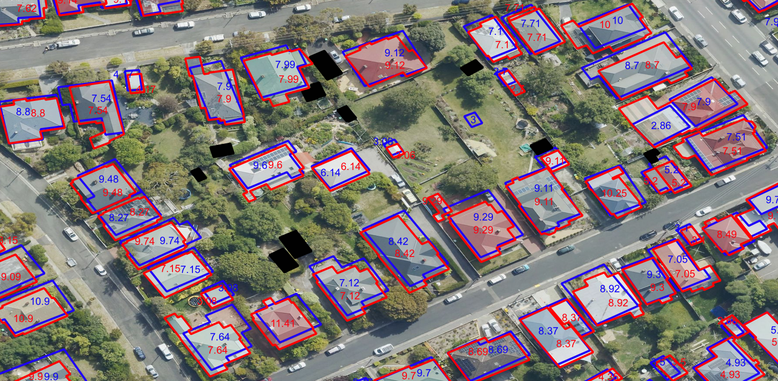
© Aerometrex Ltd Aerial Imagery [Aerometrex, 2023]
There will be cases where previous satellite-captured buildings have been knocked down and redeveloped with buildings of a different height. This would result in an incorrect height being assigned, however, we expect this to only occur in a small percentage of examples as single-dwelling residences do not often change in this way. The example below shows a large satellite-captured building that has been knocked down and replaced with residential dwellings, for which the previous satellite-captured building height has been assigned. You will also notice that as this is a greenfield development area, many of the new surrounding buildings (black) have no height information as no previously existing satellite-captured buildings were present.
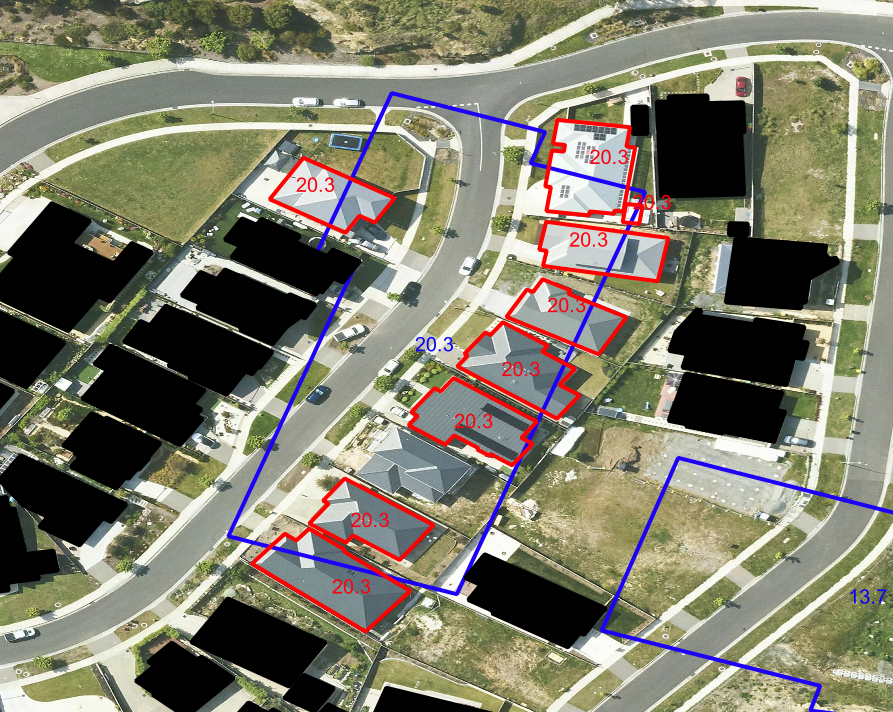
© Aerometrex Ltd Aerial Imagery [Aerometrex, 2023]
Please be aware that where there is a small shed or garage next to a residence on a property, the shed may inherit the height of the residence due to the spatial overlap with the satellite-captured building if the previous capture merged the two separate buildings as one feature.
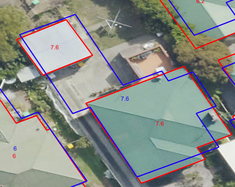
© Aerometrex Ltd Aerial Imagery [Aerometrex, 2023]
The overlap assignment method can occasionally produce an incorrect result where buildings with different heights are located together.
© Aerometrex Ltd Aerial Imagery [Aerometrex, 2023]
Improvements to address attribute in building_address table
Geoscape intends to expand unit type values from short form to long form for the address attribute within the building_address table for the March 2024 release. We are applying this change to improve the clarity of the address label and better align it with our other addressing products. An example of this change is shown below:
December 2023 short-form unit type:
EUREKA MARDROSS GARDENS ALBURY TNHS 31 33 MARDROSS CT, NORTH ALBURY NSW 2640
March 2024 long-form unit type:
EUREKA MARDROSS GARDENS ALBURY TOWNHOUSE 31 33 MARDROSS CT, NORTH ALBURY NSW 2640
This change will not affect address_pid values within this table.
Removal of the ‘Documents’ folder from data packages
From November 2023, Geoscape will be progressively moving product descriptions, guides and reports online to https://docs.geoscape.com.au
Commencing with the May 2024 release, data packages will no longer include the Documents folder.
Issues
New Issues
No new issues to note.
Resolved Issues
No resolved issues to note.
Known Issues
roof_material classification
Over classification of buildings with a primary roof material of ‘Tile’. Geoscape Australia continues to work with its partners to improve the techniques used in the classification of roof materials. For further information please refer to Classification Correctness - Building Roof/Roof Material in the product description.
Centroid not within building polygon
When mapping the building centroid from the centroid_longitude and centroid_latitude there will be occurrences where the point does not fall inside the building geometry. This occurs because of the complexity of the building geometry and impacts < 0.1% of buildings. A fix for this issue will be investigated for a future release.
Swimming_pool_adjacent incorrectly ‘null’
Some records containing attribution for swimming_pool_review_date also contain ‘null’ attribution for swimming pool adjacent where the allowed values are ‘no’ or ‘yes’. This affects < 0.25% of buildings.
Duplication of buildings between update areas
New and updated buildings are captured within Areas of Interest (AOIs). Buildings that intersect two adjacent AOIs are duplicated. This issue affects approximately 1,800 buildings.
Duplicate building polygons
There are 8,417 buildings with duplicate geometries, resulting in 8,427 additional building polygons present. A fix for this issue will be investigated for a future release.
Roof colour assignment
There is an over classification of light roof colours primarily in the Melbourne region. Advances in processing has improved this issue in recent releases.
Building position offset from imagery
There is evidence of buildings having a horizontal shift of approximately 0.5m in the NSW suburbs of Parramatta and the Dee Why area. This has occurred where the new shift to the digital elevation model has not worked as intended. As we continue to refine the aerial derived building processes, we’ll seek to resolve this issue.
Over-capture of metal roof material in aerial supplies
In the June 2022 release, we have noticed that there is an over-capture of Metal roof type in the aerial capture. This occurred primarily for residential buildings. In some areas of the new aerial capture (e.g. Perth and Cairns), Metal classification was actually improved overall in relation to the previous satellite capture (satellite previously incorrectly classified Metal roofs as Tile). We are working with our production partners to improve the accuracy of the roof_material attribute, which can be affected by image smoothing, causing Tile roofs to be incorrectly classified as Metal.
Future Considerations
This section outlines enhancements or changes under consideration, but not planned into a specific release. For further details on future initiatives, please contact Geoscape Support.
Legacy ‘CAD’ naming
The building_cad table contains a field that is called ‘cad_pid’, while the Cadastre product has an attribute called ‘cadastre_pid’. We have input the ‘cadastre_pid’ values into this ‘cad_pid’ field to not affect customer processes with attribute name changes. In addition the table name of ‘building_cad’ no longer matches the Cadastre product. There is no current plan to change either the ‘building_cad’ table name or ‘cad_pid’ field name.
Additional Total Floor Area attribute
Geoscape intends to introduce a new total_floor_area attribute to a future release of the Geoscape Buildings product. This attribute will provide the estimated sum of floor space across all levels of a building. At the time of the addition of this new attribute there will be a minor increment to the Geoscape Buildings product version.
Annex A – Release Counts
For the buildings table the additional, retired, updated and total building counts, as well as the percent change to the previous release have been listed in the table below. For the aspatial tables the total record counts have been listed.
TABLE |
ACT |
NSW |
NT |
OT |
QLD |
SA |
TAS |
VIC |
WA |
TOTAL |
||
|---|---|---|---|---|---|---|---|---|---|---|---|---|
buildings |
Additional |
0 |
38,879 |
0 |
0 |
43,624 |
8,603 |
128,409 |
273,414 |
25,581 |
518,510 |
|
Retired |
2 |
15,497 |
0 |
0 |
12,482 |
4,639 |
47,022 |
206,969 |
13,616 |
300,227 |
||
Updated |
240,558 |
3,380,677 |
105,552 |
0 |
2,601,438 |
1,013,664 |
214,626 |
3,177,663 |
1,543,494 |
12,277,672 |
||
Total |
242,218 |
5,185,057 |
160,205 |
449 |
3,721,885 |
1,706,632 |
594,333 |
4,835,561 |
2,180,212 |
18,626,552 |
||
% Change |
0.00% |
0.45% |
0.00% |
0.00% |
0.84% |
0.23% |
15.87% |
1.39% |
0.55% |
1.19% |
||
Solar Panel |
Yes |
37,830 |
581,679 |
15,835 |
8 |
649,626 |
243,294 |
32,227 |
473,292 |
335,958 |
2,369,749 |
|
No |
202,823 |
3,664,202 |
111,233 |
329 |
2,463,125 |
1,106,910 |
403,908 |
3,547,433 |
1,426,234 |
12,926,197 |
||
Swimming Pool Adjacent |
Yes |
17,889 |
662,305 |
38,978 |
0 |
749,126 |
108,853 |
9,062 |
287,164 |
306,066 |
2,179,443 |
|
No |
222,866 |
3,596,254 |
87,561 |
355 |
2,372,862 |
1,239,920 |
430,050 |
3,749,984 |
1,460,573 |
13,160,425 |
||
building_cad |
287,946 |
11,723,461 |
322,867 |
554 |
5,583,965 |
2,198,476 |
719,561 |
9,212,288 |
4,358,882 |
34,408,000 |
||
building_property |
251,227 |
6,216,107 |
262,819 |
0 |
5,577,312 |
2,126,383 |
625,944 |
11,124,372 |
2,193,235 |
28,377,399 |
||
building_address |
693,797 |
9,926,371 |
240,339 |
75 |
5,687,573 |
2,161,821 |
666,246 |
7,747,284 |
3,474,487 |
30,597,993 |
References
Aerometrex. Aerial imagery. Raster Dataset, 2023. URL: https://aerometrex.com.au/.
Geoscape. Local government areas 2.0. 2023. URL: https://docs.geoscape.com.au/projects/lga_guide/en/stable/index.html.