Building First Floor Elevation
Insight Pack
Disclaimer
Overview
First Floor Elevation (FFE) Insights provide information on how a building sits relative to the ground, helping to understand the height of the lowest habitable floor and how a property interacts with its surroundings.
Derived from analysis of street-level imagery and Geoscape data, the insight offers a building-level view of elevation alongside additional indicators such as the presence of a basement or garage, and whether the entrance to the building is raised.
Together, these attributes provide useful context on building structure and accessibility, supporting uses such as risk assessment, flood modelling, and property analysis. The insights are linked to both address and building records, enabling them to be easily integrated into broader geospatial workflows.
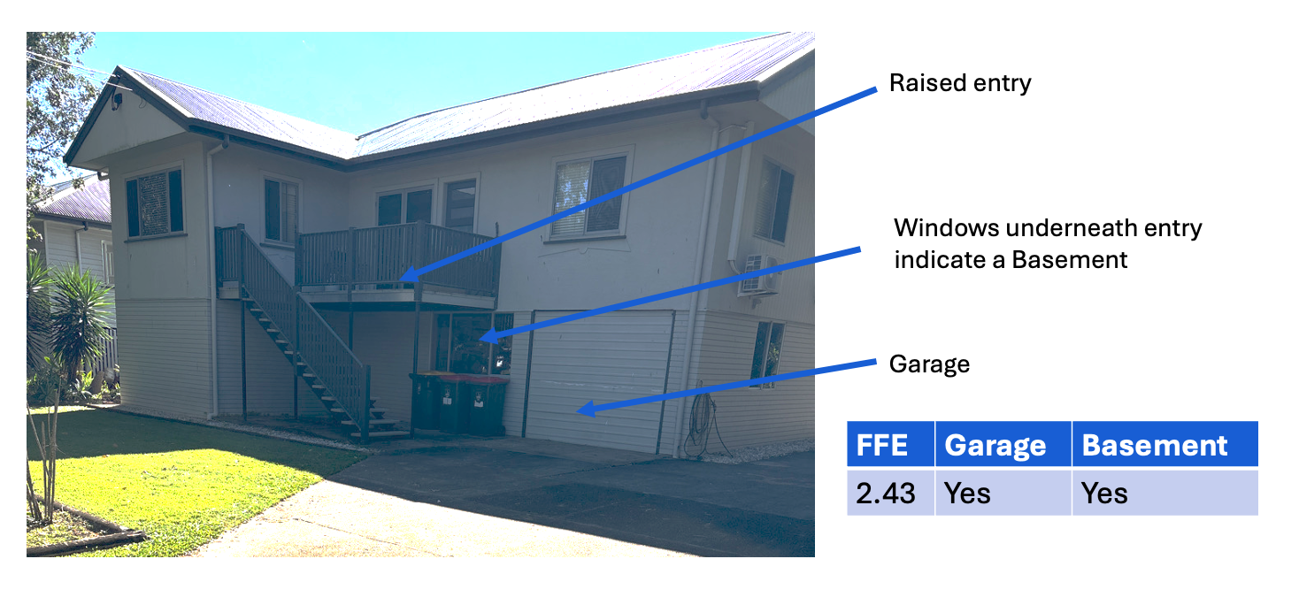
Example illustrating how First Floor Elevation insights are derived from imagery, identifying a raised entrance, basement indicators below entry level, and garage presence to support building-level analysis.
Detailed attribute definitions are provided in the technical description section.
Frequency and Currency
The Building First Floor Elevation Insight Pack is updated on request only.
The currency of individual building first floor elevation records may vary across the dataset depending on when they were last captured or updated. Relevant dates are provided as attributes in the dataset.
Technical Description
Coverage
The Building First Floor Elevation Insight Pack references buildings with first floor elevation information associated. A building in the Buildings product that has not been assessed for first floor elevation information will not be represented in the Building First Floor Elevation Insight Pack.
Linkages
The building_pid attribute can be used to link the Building First Floor Elevation Insight Pack building_first_floor_elevation table to the Buildings product buildings table. This is a 1:1 relationship - a building_first_floor_elevation record will link to only one buildings record.
Attribution
Date Information
The data model includes several dates describing the currency of the records within the product. The capture dates of the imagery utilised to derive the buildings information are provided in the date_last_captured (most recent capture of a feature). This provides temporal context for the derived attributes and enables users to understand the currency of the observation relative to real-world conditions.
The first date at which a record was created within the dataset is captured in the date_created attribute, while the date_modified is populated if the record has been updated since the original capture.
Image Information
First Floor Elevation insights are derived from the analysis of imagery sources associated with each building record. Image metadata is provided to support transparency on how and when attributes have been derived.
The capture_method describes the type of imagery used to derive the insight. First Floor Elevation is primarily derived from terrestrial (street-level) imagery, which enables detailed observation of building entry points, steps, and below-entry features required to infer elevation and related attributes.
Where multiple imagery sources are available, the most suitable imagery is selected based on coverage and visibility of relevant building features. In cases where imagery is unavailable, obscured, or of insufficient quality, derived attributes may be null.
First Floor Elevation
The first_floor_elevation attribute represents the elevation, in metres, of the building’s lowest habitable floor relative to ground level. The value is measured as the vertical distance from the ground surface at the building to the entry point of the building, where the habitable floor is accessed.
As the measurement is relative to the ground at the building location, the first floor elevation describes how the building sits above its immediate surroundings rather than an absolute height. This enables the attribute to be used in conjunction with ground elevation datasets to derive an absolute elevation for the habitable floor. In such cases, the first floor elevation value can be combined with the corresponding building ground elevation to determine the total elevation of the first habitable floor.
The first_floor_elevation_confidence attribute provides a quantified measure of confidence in the assigned elevation value, reflecting the availability and quality of source data used in its derivation.
Garage & Basement
The garage and basement attributes indicate the presence of a garage or basement associated with the primary residence building. These values are derived from imagery interpretation and are populated as Yes or No where observable.
A basement is defined, in the context of this dataset, as a building level that is located below the entry level and is identifiable through observable features in imagery. Identification is informed by indicators such as windows or openings positioned below the base level of entry doors.
Where a basement is identified or assessed, the reliability of this attribution is dependent on the visibility of below-entry features and the quality of available imagery; where sufficient evidence is not available, the attribute may be left null.
Raised Entrance
The raised_entrance attribute indicates whether an entrance to a building is elevated above ground level.
The attribute provides supporting context for interpreting first floor elevation by indicating whether a building’s entry point is raised relative to the surrounding ground surface. This can assist in identifying buildings where the lowest habitable floor is elevated above ground level.
This attribute is derived from the analysis of street-level imagery and reflects the vertical relationship between the ground level and the building entry point. Identification is informed by observable features such as the presence of steps, elevated thresholds, or other structural indicators that suggest the entrance is not at ground level. Where sufficient visual evidence is not available, or imagery is obscured or incomplete, the attribute may be recorded as null.
Data format
The Building First Floor Elevation Insight Pack is provided in the Pipe-Separated Values (PSV) file format and is an aspatial file.
More Information
For more information on the Building First Floor Elevation Insight Pack please contact Geoscape Australia Support.
Data Model
![digraph G {
fontname="ROBOTO" fontsize="10pt"
node [fontname="ROBOTO" fontsize="8pt"]
edge [fontname="ROBOTO" fontsize="8pt"]
building_first_floor_elevation [shape=plain
label=<<TABLE BGCOLOR="#FFD966"
BORDER="1"
CELLBORDER="0"
style="rounded"
CELLSPACING="0"
CELLPADDING="5">
<TR>
<TD COLSPAN="2">building_first_floor_elevation</TD>
</TR>
<TR>
<TD BGCOLOR="white" >PK</TD>
<TD BGCOLOR="white" ALIGN="LEFT" >building_pid: varchar (15) </TD>
</TR>
<TR>
<TD BGCOLOR="white" ></TD>
<TD BGCOLOR="white" ALIGN="LEFT" >date_created: date </TD>
</TR>
<TR>
<TD BGCOLOR="white" ></TD>
<TD BGCOLOR="white" ALIGN="LEFT" >date_modified: date </TD>
</TR>
<TR>
<TD BGCOLOR="white" ></TD>
<TD BGCOLOR="white" ALIGN="LEFT" >date_last_captured: date </TD>
</TR>
<TR>
<TD BGCOLOR="white" ></TD>
<TD BGCOLOR="white" ALIGN="LEFT" >capture_method: varchar (30) </TD>
</TR>
<TR>
<TD BGCOLOR="white" ></TD>
<TD BGCOLOR="white" ALIGN="LEFT" >first_floor_elevation: numeric (4,2) </TD>
</TR>
<TR>
<TD BGCOLOR="white" ></TD>
<TD BGCOLOR="white" ALIGN="LEFT" >first_floor_elevation_confidence: integer (3) </TD>
</TR>
<TR>
<TD BGCOLOR="white" ></TD>
<TD BGCOLOR="white" ALIGN="LEFT" >basement_flag: varchar (3) </TD>
</TR>
<TR>
<TD BGCOLOR="white" ></TD>
<TD BGCOLOR="white" ALIGN="LEFT" >basement_confidence: integer (3) </TD>
</TR>
<TR>
<TD BGCOLOR="white" ></TD>
<TD BGCOLOR="white" ALIGN="LEFT" >garage_flag: varchar (3) </TD>
</TR>
<TR>
<TD BGCOLOR="white" ></TD>
<TD BGCOLOR="white" ALIGN="LEFT" >garage_confidence: integer (3) </TD>
</TR>
<TR>
<TD BGCOLOR="white" ></TD>
<TD BGCOLOR="white" ALIGN="LEFT" >raised_entrance_flag: varchar (3) </TD>
</TR>
<TR>
<TD BGCOLOR="white" ></TD>
<TD BGCOLOR="white" ALIGN="LEFT" >raised_entrance_confidence: integer (3) </TD>
</TR>
<TR>
<TD BGCOLOR="white" ></TD>
<TD BGCOLOR="white" ALIGN="LEFT" >state: varchar (3) </TD>
</TR>
</TABLE>>];
}](_images/graphviz-0928a34a00c4e592e936948ca71c13c302aca741.png)
Data Dictionary
This data dictionary is applicable for the building_first_floor_elevation insights pack.
Attribute |
Data Type |
Description |
Primary Key |
Mandatory |
10 Character Alias |
|---|---|---|---|---|---|
building_pid |
character string (15) |
Persistent identifier for the building. |
Yes |
Yes |
BLD_PID |
date_created |
date (yyyy-mm-dd) |
The date of record creation for the building_first_floor_elevation record. |
No |
Yes |
DT_CREATE |
date_modified |
date (yyyy-mm-dd) |
The most recent date that an attribute has been modified for the building_first_floor_elevation record. |
No |
No |
DT_MOD |
date_last_captured |
date (yyyy-mm-dd) |
The most recent date that the building first floor elevation information was captured for the building. The date_last_captured will match the date_first_captured if there has only been one capture for the building_pid. |
No |
Yes |
DT_LST_CPT |
capture_method |
character string (30) |
Type of source used to capture the first floor elevation of the building (e.g. Street Level Imagery). |
No |
Yes |
CAPT_MTHD |
first_floor_elevation |
number (4,2) |
The height above ground level of the lowest habitable floor in metres as assessed from the street-facing side of the house. |
No |
Yes |
FFE |
first_floor_elevation_confidence |
number (5,2) |
The confidence in the assignment of the first floor elevation for the building as a percentage. |
No |
Yes |
FFE_CONF |
basement_flag |
character string (3) |
A ‘Yes’ value indicates that a basement has been identified for the building. |
No |
No |
BASMNT_FLG |
basement_confidence |
number (5,2) |
The confidence in the assignment of the basement for the building as a percentage. |
No |
No |
BASMNT_CON |
garage_flag |
character string (3) |
A ‘Yes’ value indicates that a garage has been identified for the building. |
No |
No |
GARAGE_FLG |
garage_confidence |
number (5,2) |
The confidence in the assignment of the garage flag for the building as a percentage. |
No |
No |
GARAGE_CON |
raised_entrance_flag |
character string (3) |
A ‘Yes’ value indicates that an entrance above the ground floor has been identified for the building. |
No |
No |
RSD_ENT_FL |
raised_entrance_confidence |
number (5,2) |
The confidence in the assignment of the raised entrance flag for the building as a percentage. |
No |
No |
RSD_ENT_CO |
state |
character string (3) |
The abbreviated name of the State or Territory that the building is primarily within. |
No |
Yes |
STATE |