National Local Government Areas
Disclaimer
Overview
National Local Government Areas is a spatial representation of the administrative divisions that local governments are responsible for across Australia defined by State and Territory governments. The dataset aggregates the representations unique to each jurisdiction into a consistent seamless representation of the local government areas of Australia.
Geoscape welcomes your feedback on the National Local Government Areas product. We also publish regular product development updates on our website ( www.geoscape.com.au ).
Release Summary
This product was released to customers on 18 May 2026 with data extracted on 8 May 2026.
This release is a full national data population for Version 2.1 of the National Local Government Areas product, described by the National Local Government Areas Product Guide v2.1.
Any issues that have been identified for this release are described in the Issues section.
Change Notifications
Versioning Update (Effective June 2026)
Beginning June 2026, all data products will transition to a standardised versioning format: MAJOR-MINOR-EXTRACT (e.g., 004-000-001). This approach provides a clear and consistent structure, making it easier for users to identify product versions and understand update levels at a glance. The change is intended to improve transparency, reduce ambiguity, and support more efficient integration and usage of our data products.
Implementation of New Zip File Naming and Packaging Standards (Starting August 2026)
As part of ongoing improvements to product consistency and packaging standards, updates to zip file naming conventions and internal packaging structure will be implemented, starting in August 2026.
Zip File Naming
Two standard naming patterns will be used, depending on whether an extract contains spatial information:
Spatial Tables:
{PRODUCT-NAME}_{RELEASE YYYYMM}_{REGION}_{CRS}_{FORMAT}_{VERSION MAJOR-MINOR-EXTRACT}.zip
Aspatial (Insights) Tables:
{PRODUCT-NAME}_{RELEASE YYYYMM}_{REGION}_NODATUM_{FORMAT}_{VERSION MAJOR-MINOR-EXTRACT}.zip
Packaging Structure
All zip files will follow a simplified, flat directory layout:
No nested folders
The primary data file will be located at the top level of the zip.
Note: The product package will no longer include supporting content.txt files.
These changes ensure consistent packaging across all products, reduce complexity, and support improved automation and user experience.
Updates
New and Retired
New
New lga records:
lga_pid |
lga_name |
state |
|---|---|---|
lgaVgu0GvW1EC5u |
Shire of Cocos (Keeling) Islands |
OT |
'N/A' indicates that no records of this type exist
New lga_locality records:
lga_locality_pid |
lga_pid |
lga_name |
locality_pid |
locality_name |
state |
|---|---|---|---|---|---|
lgljg_pUnAetwSJ |
lgae04a9b8beff3 |
The Hills Shire Council |
loc70f6a92b24c0 |
Winston Hills |
NSW |
lglPHq-t7KcJuzu |
lgaVgu0GvW1EC5u |
Shire of Cocos (Keeling) Islands |
loc2750e00db227 |
Home Island |
OT |
lglsCpcQe5dvfee |
lgaVgu0GvW1EC5u |
Shire of Cocos (Keeling) Islands |
loc82a2b1f10de5 |
West Island |
OT |
'N/A' indicates that no records of this type exist
Retired
Retired lga records:
lga_pid |
lga_name |
state |
|---|---|---|
lgavVLPwROnK-AV |
Shire Cocos (Keeling) Islands |
OT |
'N/A' indicates that no records of this type exist
Retired lga_locality records:
lga_locality_pid |
lga_pid |
lga_name |
locality_pid |
locality_name |
state |
|---|---|---|---|---|---|
lglB3RgWlQVPl1T |
lgavVLPwROnK-AV |
Shire Cocos (Keeling) Islands |
loc2750e00db227 |
Home Island |
OT |
lglyOXUGnIA1T3- |
lgavVLPwROnK-AV |
Shire Cocos (Keeling) Islands |
loc82a2b1f10de5 |
West Island |
OT |
'N/A' indicates that no records of this type exist
Spatial Changes
Spatial changes (area) greater than 1 km2 are shown below:
lga_pid |
lga_name |
state |
Difference_SQKM |
Old_SQKM |
New_SQKM |
|---|---|---|---|---|---|
N/A |
N/A |
N/A |
N/A |
N/A |
N/A |
'N/A' indicates that no records of this type exist
Other Updates
There were no other updates.
Issues
New Issues
No new issues.
Resolved Issues
No resolved issues to note.
Known Issues
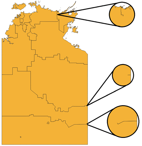
Un-enclosed gaps between Local Government Areas in NT
There are three un-enclosed gaps present in the National Local Government Areas data in NT. These gaps are not valid and do not represent rivers. Below, the un-enclosed gaps can be seen between polygons when they are dissolved together.
SA coastline generalisation for The DC of Grant
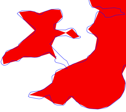
Jurisdictional changes to the coastline geometry have resulted in polygon generalisation for ‘The DC of Grant’ LGA in South Australia. This has reduced the number of vertices in the polygons resulting in geometry differences and, in some scenarios, the creation of new polygons for the LGA. Below is an example where the previous Admin Boundaries LGA outline (blue) can be seen compared to the new National Local Government Area product representation (red area).
Geoscape is currently investigating this generalisation with the SA jurisdiction.
Single VIC lga_locality linkage not made
The LGA named ‘Mount Buller Alpine Resort (Unincorporated)’ (lga_pid = lga69dad94a9718) does not link to the ’Mount Buller’ locality (locality_pid = ‘loc8688ba223de1’) record despite new rules which allow small LGAs that are contained within, or have large overlap with, a locality.
Future Considerations
This section outlines enhancements or changes under consideration, but not planned into a specific release. For further details on future initiatives, please contact Geoscape Support.
Annex A – Release Counts
Additional, retired and total National Local Government Areas counts and the percent change to the previous release have been listed in the table below.
TABLE |
STATISTIC |
ACT |
NSW |
NT |
OT |
QLD |
SA |
TAS |
VIC |
WA |
TOTAL |
|---|---|---|---|---|---|---|---|---|---|---|---|
lga |
Additional |
0 |
31 |
0 |
2 |
16 |
13 |
5 |
0 |
45 |
112 |
Retired |
0 |
31 |
0 |
2 |
15 |
13 |
5 |
0 |
45 |
111 |
|
Updated |
0 |
0 |
0 |
0 |
0 |
0 |
0 |
0 |
0 |
0 |
|
Total |
0 |
198 |
800 |
3 |
210 |
173 |
533 |
92 |
201 |
2,210 |
|
% Change |
0.00% |
0.00% |
0.00% |
0.00% |
0.48% |
0.00% |
0.00% |
0.00% |
0.00% |
0.05% |
|
lga_locality |
Total |
0 |
5,044 |
319 |
3 |
3,344 |
2,078 |
888 |
3,339 |
1,753 |
16,768 |