Cadastre LULC Insight Pack
Disclaimer
Overview
The Cadastre LULC (Land Use and Land Cover) Insight Pack provides cadastre-level land use and land cover classification data across Australia. This product delivers high-level land classification that enables broad environmental monitoring, carbon accounting, and land use analysis.
Product Purpose
This insight pack provides the foundational land use classification layer (cadastre_lulc) that categorises every cadastre polygon by its dominant land use across a yearly time series. The data supports:
Broad land cover monitoring for environmental reporting and carbon accounting
Foundation layer for more detailed agricultural and forest analysis
Integration with Geoscape Cadastre for spatial analysis and visualisation
Product Structure
The cadastre_lulc table classifies every cadastre polygon by land use category. This top-level classification forms the basis for two specialised detail tables:
cadastre_forest - Provides forest structure detail for polygons classified as “Forest”
cadastre_crop - Provides crop type and harvest detail for polygons classified as “Crop Land”
Customers can subscribe to this LULC table independently or combine it with the specialised Forest and Crop insight packs for comprehensive land use intelligence.
Key Features
Geographic Coverage
This product covers approximately 5.8 million square kilometers of agricultural land across Australia, encompassing approximately 3 million Geoscape Cadastre parcels.
Agricultural areas are identified by combining the Geoscape Planning product with the Australian Land Use and Management (ALUM) Classification, published by ABARES.
Temporal Resolution
The cadastre_lulc table provides yearly temporal resolution, with classifications representing the dominant land use observed for each reporting year.
While most land use classes are determined from observations captured during the reporting year, the forest class is derived using a longer temporal assessment period. This approach analyses vegetation patterns over multiple observations to distinguish persistent forest cover from short-term land cover changes, resulting in a more stable and reliable forest classification. Consequently, forest classifications may incorporate observations spanning up to several years rather than a single annual snapshot.
Spatial Integration
Data is spatially enabled by joining to the Geoscape Cadastre product via the cadastre_polygon_pid field. This allows customers to associate land use classification data with cadastral geometries for spatial analysis and visualisation.
Delivery Format
Data is delivered as PSV (Pipe Separated Value) files with .psv extension, compatible with relational database applications and spreadsheet tools. PSV format uses the pipe character ( | ) as the field delimiter, avoiding ambiguity with comma-delimited formats where field values may contain commas.
Use Cases
This insight pack supports various land management and environmental analysis scenarios:
- Environmental Reporting and Carbon Accounting
The LULC table provides broad land cover classification suitable for environmental monitoring, greenhouse gas inventory reporting, and carbon credit assessment.
- Foundation for Detailed Analysis
Use as the base layer to identify areas of interest, then drill into specialised detail using the Forest or Crop insight packs for parcels requiring additional resolution.
- Land Use Change Detection
Yearly time series enables tracking of land use transitions across cadastral parcels over time.
Technical Description
Agricultural Extent Definition
Agricultural areas were identified by combining the Geoscape Planning product with the Australian Land Use and Management (ALUM) Classification, published by the Australian Bureau of Agricultural and Resource Economics and Sciences (ABARES). Together, these datasets provide the foundation for determining which areas can be classified as agricultural land.
Further information on the ALUM classification framework is available at the Australian Land Use and Management Classification Version 8 (October 2016) - DAFF.
Exclusions from Agricultural Classification
The following areas are explicitly excluded from agricultural land classification:
Urban parcels - Parcels falling within Urban Centres and Localities (UCL) boundaries, as defined in the Australian Statistical Geography Standard (ASGS) Edition 3. Further information is available at Urban Centres and Localities.
Stock routes - Linear corridors reserved for the movement of livestock are excluded from the agricultural classification.
Spatial Coverage and Tiling
The agricultural extent is partitioned into 100km × 100km tiles aligned to Map Grid of Australia (MGA) projection zones. The defined agricultural outline is used to identify which tiles intersect agricultural land — these qualifying tiles determine the scope of imagery sourced and processed for the product.
All cadastral parcels within the qualifying tiles that intersect the defined agricultural boundary are included in the final product.
This approach ensures:
Consistent spatial partitioning aligned to MGA projection zones
Complete cadastral coverage within agricultural regions — no parcels are partially included
Predictable, tile-based delivery suitable for large-scale data processing
Imagery Sources
Classification is derived from Copernicus Sentinel-2 satellite imagery. Imagery acquisition, processing methodology, and temporal coverage details are subject to ongoing refinement.
Cadastral Area Calculation
Area has been calculated using a parcel’s relevant GDA2020 MGA zone. When, due to the size of a parcel, a record is split between two MGA zones, the area is split into two parts favoring the leftmost MGA zone: 7850 > 7851 > 7852 > 7853 > 7854 > 7855 > 7856.
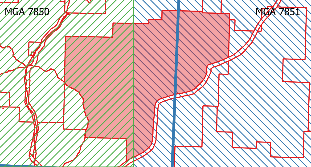
The diagram illustrates a parcel (shaded) that straddles two MGA zones — MGA 7850 (left, green hatching), MGA 7851 (right, blue hatching) and a Tile boundary (blue line).
Coverage Area and Percentage Attributes
Coverage Area
The coverage_area attribute represents the distinct summed area based on the combination of land use category, crop/forest class, and class subtype for a cadastral polygon part.
Some coverage areas may have an area of 0m². These have been maintained to assist in explaining where the sum of Agricultural Land Use records do not match the area of the cadastral parcel.
Coverage Percentage
The coverage_pct attribute represents the percentage of the total polygon area covered by a class/subtype. Because of rounding, it is possible for the sum of coverage_pct grouped by a cadastre_polygon_pid to be greater than 100% (e.g. 100.02%).
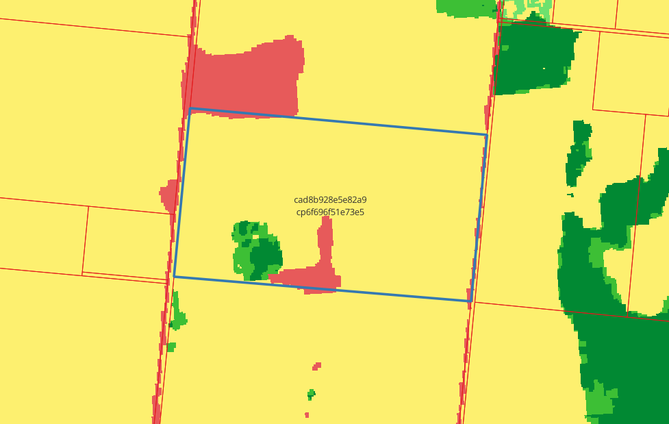
Example of LULC classification for there cadastre parcel where cadastre_pid = ‘cad8b928e5e82a9’ and cadastre_polygon_pid = ‘cp6f696f51e73e5’.
cadastre_lulc_pid |
cadastre_polygon_pid |
cadastre_pid |
year |
state |
total_cadastre_area |
lulc_class |
coverage_area |
coverage_pct |
|---|---|---|---|---|---|---|---|---|
aglk7SGgxF5c5Vd |
cp6f696f51e73e5 |
cad8b928e5e82a9 |
2025 |
NSW |
1394622.48 |
Forest |
31900 |
2.29 |
aglNycKGHfl7qD- |
cp6f696f51e73e5 |
cad8b928e5e82a9 |
2025 |
NSW |
1394622.48 |
Crop Land |
1259328.84 |
90.30 |
aglTnKxtQMUX4I3 |
cp6f696f51e73e5 |
cad8b928e5e82a9 |
2025 |
NSW |
1394622.48 |
Built Up |
68493.63 |
4.91 |
aglB7vt_om8s40j |
cp6f696f51e73e5 |
cad8b928e5e82a9 |
2025 |
NSW |
1394622.48 |
Range Land |
34900 |
2.5 |
Data Model
![digraph G {
fontname="ROBOTO" fontsize="10pt"
node [fontname="ROBOTO" fontsize="8pt"]
edge [fontname="ROBOTO" fontsize="8pt"]
cadastre_lulc [shape=plain
label=<<TABLE BGCOLOR="#FFD966"
BORDER="1"
CELLBORDER="0"
style="rounded"
CELLSPACING="0"
CELLPADDING="5">
<TR>
<TD COLSPAN="2">cadastre_lulc</TD>
</TR>
<TR>
<TD BGCOLOR="white" >PK</TD>
<TD BGCOLOR="white" ALIGN="LEFT" >cadastre_lulc_pid: varchar (15) </TD>
</TR>
<TR>
<TD BGCOLOR="white" >FK</TD>
<TD BGCOLOR="white" ALIGN="LEFT" >cadastre_polygon_pid: varchar (15) </TD>
</TR>
<TR>
<TD BGCOLOR="white" >FK</TD>
<TD BGCOLOR="white" ALIGN="LEFT" >cadastre_pid: varchar (15) </TD>
</TR>
<TR>
<TD BGCOLOR="white" ></TD>
<TD BGCOLOR="white" ALIGN="LEFT" >year: number (4) </TD>
</TR>
<TR>
<TD BGCOLOR="white" ></TD>
<TD BGCOLOR="white" ALIGN="LEFT" >state: varchar (3) </TD>
</TR>
<TR>
<TD BGCOLOR="white" ></TD>
<TD BGCOLOR="white" ALIGN="LEFT" >total_cadastre_area: number (14,2) </TD>
</TR>
<TR>
<TD BGCOLOR="white" ></TD>
<TD BGCOLOR="white" ALIGN="LEFT" >lulc_class: varchar (20) </TD>
</TR>
<TR>
<TD BGCOLOR="white" ></TD>
<TD BGCOLOR="white" ALIGN="LEFT" >coverage_area: number (14,2) </TD>
</TR>
<TR>
<TD BGCOLOR="white" ></TD>
<TD BGCOLOR="white" ALIGN="LEFT" >coverage_pct: number (5,2) </TD>
</TR>
</TABLE>>];
}](_images/graphviz-9933b83e0b2200e71c85b4b4866f9c55fa785e77.png)
Data Dictionary
Table: cadastre_lulc
The top-level land use classification table. Each row describes the coverage of a land use class for a given cadastre polygon in a given year.
Columns
Column |
Type |
Nullable |
Description |
|---|---|---|---|
cadastre_lulc_pid |
character string(15) |
NOT NULL |
Primary key — unique identifier for this record |
cadastre_polygon_pid |
character string(15) |
NOT NULL |
Unique persistent identifier for the cadastre polygon |
cadastre_pid |
character string(15) |
NOT NULL |
Persistent identifier for the cadastral feature for the life of the lot’s title |
year |
number(4) |
NOT NULL |
Calendar year the coverage data relates to |
state |
character string(3) |
NOT NULL |
Australian state or territory code — see domain values |
total_cadastre_area |
number(14,2) |
NOT NULL |
Total area of the cadastre polygon (square metres) |
lulc_class |
character string(20) |
NOT NULL |
Land use / land cover classification — see domain values |
coverage_area |
number(14,2) |
NOT NULL |
Area of the cadastre polygon covered by this land use class (square metres) |
coverage_pct |
number(5,2) |
NOT NULL |
Coverage area as a percentage of the total cadastre area |
Notes
Crop Land rows represent the total cropped area for a cadastre polygon. For crop class and crop name breakdowns, see the Cadastre Crop Insight Pack (
cadastre_croptable).Forest rows represent the total forested area for a cadastre polygon. For forest structure classification, see the Cadastre Forest Insight Pack (
cadastre_foresttable).
Domain Values: lulc_class
Value |
Description |
|---|---|
Waterbody |
Areas where water is predominantly present throughout the year, including natural and artificial water features such as lakes, ponds, and irrigation reservoirs |
Built Up |
Human-made structures and large impervious surfaces, including roads, rail networks, buildings, and residential housing |
Pasture/Fallow |
Areas described as the natural potential plant cover composed principally of native grasses |
Crop Land |
Landscapes cultivated to produce food crops, including single crop land (cultivated once per year) and multiple crop land (cultivated more than once per year) |
Barren Land |
Landscapes where the surface is largely composed of little to no vegetation, typically devoid of significant soil development |
Plantation/Trees |
Areas managed for the cultivation of perennial crops maintained over several years before harvest; distinct from annual cropping systems |
Range Land |
Open areas predominantly covered by natural grasses, wild cereals, and low-growing vegetation with minimal tall trees or dense plant cover |
Forest |
Areas primarily covered by trees and natural vegetation |
Domain Values: state
Value |
Description |
|---|---|
NSW |
New South Wales |
VIC |
Victoria |
QLD |
Queensland |
SA |
South Australia |
WA |
Western Australia |
TAS |
Tasmania |
ACT |
Australian Capital Territory |
NT |
Northern Territory |