Technical Description
Planning Insights is created by spatially intersecting planning zone and overlay data with Geoscape’s Cadastre product. The G-NAF (Geocoded National Address File) product is then spatially related to the linked cadastre parcels via a point (G-NAF address) in polygon (Cadastre) relationship. Source attributes are mapped and standardised to provide a coherent definition across Australia. Additional attributes have been generated and integrated by Geoscape to support the source information as well as to provide convenience in the use and representation of the dataset. Planning Insights is updated and released regularly and has integrated relationships with other Geoscape Products. Further information regarding attributes, quality, coverage, and product release details are outlined below.
Linkages
Planning Insights is integrated with the following Geoscape products:
Cadastre [1]
G-NAF
Planning Insights uses simple spatial intersection to provide the relationship between a parcel and planning zones or overlays (for example, flood, bushfire or heritage overlays). If any part of a planning zone or overlay overlaps a parcel, it will be associated with the parcel, even if it does not overlap with the area of the parcel where a building is located.
The joins used to link to these products are shown below, with attributes used in the joins described.
![digraph G {
graph [pad="0.5", ranksep="1"];
fontname="ROBOTO" fontsize="10pt"
node [fontname="ROBOTO" fontsize="8pt"]
edge [fontname="ROBOTO" fontsize="8pt"]
rankdir=LR; nodesep=0.5;
subgraph cluster_planning_insights { label="Planning Insights"
graph[style="dashed,rounded" color="#EA6B66"]
planning_insights [shape=plain
label=<<TABLE BGCOLOR="#FFD966"
BORDER="1"
CELLBORDER="0"
style="rounded"
CELLSPACING="0"
CELLPADDING="5">
<TR>
<TD COLSPAN="2">planning_insights</TD>
</TR>
<TR>
<TD BGCOLOR="white" >PK</TD>
<TD BGCOLOR="white" ALIGN="LEFT" >pi_pid: varchar (15) </TD>
</TR>
<TR>
<TD BGCOLOR="white" >FK</TD>
<TD BGCOLOR="white" ALIGN="LEFT" >base_cadastre_pid: varchar (15) </TD>
</TR>
<TR>
<TD BGCOLOR="white" ></TD>
<TD BGCOLOR="white" ALIGN="LEFT" >date_created: date</TD>
</TR>
<TR>
<TD BGCOLOR="white" ></TD>
<TD BGCOLOR="white" ALIGN="LEFT" >state: varchar (3) </TD>
</TR>
<TR>
<TD BGCOLOR="white" ></TD>
<TD BGCOLOR="white" ALIGN="LEFT" >pi_zone_code: varchar (120) </TD>
</TR>
<TR>
<TD BGCOLOR="white" ></TD>
<TD BGCOLOR="white" ALIGN="LEFT" >flood: varchar (5)</TD>
</TR>
<TR>
<TD BGCOLOR="white" ></TD>
<TD BGCOLOR="white" ALIGN="LEFT" >bushfire: varchar (5)</TD>
</TR>
<TR>
<TD BGCOLOR="white" ></TD>
<TD BGCOLOR="white" ALIGN="LEFT" >infrastructure: varchar (5)</TD>
</TR>
<TR>
<TD BGCOLOR="white" ></TD>
<TD BGCOLOR="white" ALIGN="LEFT" >environment: varchar (5)</TD>
</TR>
<TR>
<TD BGCOLOR="white" ></TD>
<TD BGCOLOR="white" ALIGN="LEFT" >heritage: varchar (5)</TD>
</TR>
<TR>
<TD BGCOLOR="white" ></TD>
<TD BGCOLOR="white" ALIGN="LEFT" >industry: varchar (5)</TD>
</TR>
<TR>
<TD BGCOLOR="white" ></TD>
<TD BGCOLOR="white" ALIGN="LEFT" >permitted: varchar (2800)</TD>
</TR>
<TR>
<TD BGCOLOR="white" ></TD>
<TD BGCOLOR="white" ALIGN="LEFT" >permitted_with_controls: varchar (4800). </TD>
</TR>
<TR>
<TD BGCOLOR="white" ></TD>
<TD BGCOLOR="white" ALIGN="LEFT" >prohibited: varchar (4000)</TD>
</TR>
<TR>
<TD BGCOLOR="white" ></TD>
<TD BGCOLOR="white" ALIGN="LEFT" >permitted_use_apartment: varchar (5)</TD>
</TR>
<TR>
<TD BGCOLOR="white" ></TD>
<TD BGCOLOR="white" ALIGN="LEFT" >permitted_use_duplex: varchar (5)</TD>
</TR>
<TR>
<TD BGCOLOR="white" ></TD>
<TD BGCOLOR="white" ALIGN="LEFT" >permitted_use_mixeduse: varchar (5)</TD>
</TR>
<TR>
<TD BGCOLOR="white" ></TD>
<TD BGCOLOR="white" ALIGN="LEFT" >permitted_use_townhouse: varchar (5)</TD>
</TR>
</TABLE>>];
planning_insights_zoning [ shape=plain
label=<<TABLE BGCOLOR="#FFD966"
BORDER="1"
CELLBORDER="0"
style="rounded"
CELLSPACING="0"
CELLPADDING="5">
<TR>
<TD COLSPAN="2">planning_insights_zoning</TD>
</TR>
<TR>
<TD BGCOLOR="white" >PK</TD>
<TD BGCOLOR="white" ALIGN="LEFT" >pi_zoning_pid: varchar (15) </TD>
</TR>
<TR>
<TD BGCOLOR="white" >FK</TD>
<TD BGCOLOR="white" ALIGN="LEFT" >base_cadastre_pid: varchar (15) </TD>
</TR>
<TR>
<TD BGCOLOR="white" ></TD>
<TD BGCOLOR="white" ALIGN="LEFT" >date_created: date</TD>
</TR>]
<TR>
<TD BGCOLOR="white" ></TD>
<TD BGCOLOR="white" ALIGN="LEFT" >zone_code: varchar (120) </TD>
</TR>
<TR>
<TD BGCOLOR="white" ></TD>
<TD BGCOLOR="white" ALIGN="LEFT" >zone_label1: varchar (230) </TD>
</TR>
<TR>
<TD BGCOLOR="white" ></TD>
<TD BGCOLOR="white" ALIGN="LEFT" >zone_label2: varchar (120) </TD>
</TR>
</TABLE>>];
planning_insights_overlays [ shape=plain
label=<<TABLE BGCOLOR="#FFD966"
BORDER="1"
CELLBORDER="0"
style="rounded"
CELLSPACING="0"
CELLPADDING="5">
<TR>
<TD COLSPAN="2">planning_insights_overlays</TD>
</TR>
<TR>
<TD BGCOLOR="white" >PK</TD>
<TD BGCOLOR="white" ALIGN="LEFT" >pi_overlay_pid: varchar (15) </TD>
</TR>
<TR>
<TD BGCOLOR="white" >FK</TD>
<TD BGCOLOR="white" ALIGN="LEFT" >base_cadastre_pid: varchar (15) </TD>
</TR>
<TR>
<TD BGCOLOR="white" ></TD>
<TD BGCOLOR="white" ALIGN="LEFT" >date_created: date</TD>
</TR>]
<TR>
<TD BGCOLOR="white" ></TD>
<TD BGCOLOR="white" ALIGN="LEFT" >overlay_category: varchar (20) </TD>
</TR>
<TR>
<TD BGCOLOR="white" ></TD>
<TD BGCOLOR="white" ALIGN="LEFT" >overlay_group: varchar (120) </TD>
</TR>
<TR>
<TD BGCOLOR="white" ></TD>
<TD BGCOLOR="white" ALIGN="LEFT" >overlay_label: varchar (160) </TD>
</TR>
<TR>
<TD BGCOLOR="white" ></TD>
<TD BGCOLOR="white" ALIGN="LEFT" >overlay_value: varchar (270) </TD>
</TR>
</TABLE>>];
planning_insights_address [shape=plain
label=<<TABLE BGCOLOR="#FFD966"
BORDER="1"
CELLBORDER="0"
style="rounded"
CELLSPACING="0"
CELLPADDING="5">
<TR>
<TD COLSPAN="2">planning_insights_address</TD>
</TR>
<TR>
<TD BGCOLOR="white" >PK</TD>
<TD BGCOLOR="white" ALIGN="LEFT" >pi_address_pid: varchar (15) </TD>
</TR>
<TR>
<TD BGCOLOR="white" >FK</TD>
<TD BGCOLOR="white" ALIGN="LEFT" >address_detail_pid: varchar (15) </TD>
</TR>
<TR>
<TD BGCOLOR="white" >FK</TD>
<TD BGCOLOR="white" ALIGN="LEFT" >base_cadastre_pid: varchar (15) </TD>
</TR>
<TR>
<TD BGCOLOR="white" ></TD>
<TD BGCOLOR="white" ALIGN="LEFT" >date_created: date</TD>
</TR> ]
</TABLE>>];
planning_insights -> planning_insights_zoning [arrowhead=crownoneodot, dir=both, arrowtail=nonetee, label="base_cadastre_pid"]
planning_insights -> planning_insights_overlays [arrowhead=crownoneodot, dir=both, arrowtail=nonetee, label="base_cadastre_pid"]
planning_insights -> planning_insights_address [arrowhead=crownoneodot, dir=both, arrowtail=nonetee, label="base_cadastre_pid"]
{rank=same; planning_insights; planning_insights_address}
}
subgraph cluster_cadastre { label="Cadastre"
graph[style="dashed,rounded" color="#000000"]
cadastre [shape=plain
label=<<TABLE BGCOLOR="#7EA6E0"
BORDER="1"
CELLBORDER="0"
style="rounded"
CELLSPACING="0"
CELLPADDING="5">
<TR>
<TD COLSPAN="2">cadastre</TD>
</TR>
<TR>
<TD BGCOLOR="white" >PK</TD>
<TD BGCOLOR="white" ALIGN="LEFT" >cadastre_polygon_pid: varchar (15) </TD>
</TR>
<TR>
<TD BGCOLOR="white" ></TD>
<TD BGCOLOR="white" ALIGN="LEFT" >cadastre_pid: varchar (15) </TD>
</TR>
<TR>
<TD BGCOLOR="white" ></TD>
<TD BGCOLOR="white" ALIGN="LEFT" >contributor_id: varchar (20) </TD>
</TR>
<TR>
<TD BGCOLOR="white" ></TD>
<TD BGCOLOR="white" ALIGN="LEFT" >date_created: date </TD>
</TR>
<TR>
<TD BGCOLOR="white" ></TD>
<TD BGCOLOR="white" ALIGN="LEFT" >date_modified: date </TD>
</TR>
<TR>
<TD BGCOLOR="white" ></TD>
<TD BGCOLOR="white" ALIGN="LEFT" >state: varchar (3) </TD>
</TR>
<TR>
<TD BGCOLOR="white" ></TD>
<TD BGCOLOR="white" ALIGN="LEFT" >lot: varchar (15) </TD>
</TR>
<TR>
<TD BGCOLOR="white" ></TD>
<TD BGCOLOR="white" ALIGN="LEFT" >plan: varchar (20) </TD>
</TR>
<TR>
<TD BGCOLOR="white" ></TD>
<TD BGCOLOR="white" ALIGN="LEFT" >section: varchar (5) </TD>
</TR>
<TR>
<TD BGCOLOR="white" ></TD>
<TD BGCOLOR="white" ALIGN="LEFT" >parcel_id: varchar (60) </TD>
</TR>
<TR>
<TD BGCOLOR="white" ></TD>
<TD BGCOLOR="white" ALIGN="LEFT" >source: varchar (20) </TD>
</TR>
<TR>
<TD BGCOLOR="white" ></TD>
<TD BGCOLOR="white" ALIGN="LEFT" >contributor_status: varchar (35) </TD>
</TR>
<TR>
<TD BGCOLOR="white" ></TD>
<TD BGCOLOR="white" ALIGN="LEFT" >title_status: varchar (10) </TD>
</TR>
<TR>
<TD BGCOLOR="white" ></TD>
<TD BGCOLOR="white" ALIGN="LEFT" >parcel_type: varchar (10) </TD>
</TR>
<TR>
<TD BGCOLOR="white" ></TD>
<TD BGCOLOR="white" ALIGN="LEFT" >base_parcel: varchar (3) </TD>
</TR>
<TR>
<TD BGCOLOR="white" >FK</TD>
<TD BGCOLOR="white" ALIGN="LEFT" >base_cadastre_pid: varchar (15) </TD>
</TR>
<TR>
<TD BGCOLOR="white" ></TD>
<TD BGCOLOR="white" ALIGN="LEFT" >strata_type: varchar (10) </TD>
</TR>
<TR>
<TD BGCOLOR="white" ></TD>
<TD BGCOLOR="white" ALIGN="LEFT" >total_strata_count: number (5) </TD>
</TR>
<TR>
<TD BGCOLOR="white" ></TD>
<TD BGCOLOR="white" ALIGN="LEFT" >horizontal_strata_count: number (5) </TD>
</TR>
<TR>
<TD BGCOLOR="white" ></TD>
<TD BGCOLOR="white" ALIGN="LEFT" >vertical_strata_count: number (5) </TD>
</TR>
<TR>
<TD BGCOLOR="white" ></TD>
<TD BGCOLOR="white" ALIGN="LEFT" >area: number (12,2) </TD>
</TR>
<TR>
<TD BGCOLOR="white" ></TD>
<TD BGCOLOR="white" ALIGN="LEFT" >geometry: Polygon </TD>
</TR>
</TABLE>>];
cadastre -> planning_insights [arrowhead=noneteenoneodot, dir=both, arrowtail=crownonetee, label="base_cadastre_pid"]
}
subgraph cluster_gnaf { label="G-NAF"
graph[style="dashed,rounded" color="#000000"]
address_detail [shape=plain
label=<<TABLE BGCOLOR="#FFD966"
BORDER="1"
CELLBORDER="0"
style="rounded"
CELLSPACING="0"
CELLPADDING="5">
<TR>
<TD COLSPAN="2">ADDRESS_DETAIL</TD>
</TR>
<TR>
<TD BGCOLOR="white" >PK</TD>
<TD BGCOLOR="white" ALIGN="LEFT" >ADDRESS_DETAIL_PID: varchar (15) </TD>
</TR>
<TR>
<TD BGCOLOR="white" ></TD>
<TD BGCOLOR="white" ALIGN="LEFT" >DATE_CREATED: date </TD>
</TR>
<TR>
<TD BGCOLOR="white" ></TD>
<TD BGCOLOR="white" ALIGN="LEFT" >DATE_LAST_MODIFIED: date </TD>
</TR>
<TR>
<TD BGCOLOR="white" ></TD>
<TD BGCOLOR="white" ALIGN="LEFT" >DATE_RETIRED: date </TD>
</TR>
<TR>
<TD BGCOLOR="white" ></TD>
<TD BGCOLOR="white" ALIGN="LEFT" >BUILDING_NAME: varchar (200) </TD>
</TR>
<TR>
<TD BGCOLOR="white" ></TD>
<TD BGCOLOR="white" ALIGN="LEFT" >LOT_NUMBER_PREFIX: varchar (2) </TD>
</TR>
<TR>
<TD BGCOLOR="white" ></TD>
<TD BGCOLOR="white" ALIGN="LEFT" >LOT_NUMBER: varchar (5) </TD>
</TR>
<TR>
<TD BGCOLOR="white" ></TD>
<TD BGCOLOR="white" ALIGN="LEFT" >LOT_NUMBER_SUFFIX: varchar (2) </TD>
</TR>
<TR>
<TD BGCOLOR="white" >FK</TD>
<TD BGCOLOR="white" ALIGN="LEFT" >FLAT_TYPE_CODE: varchar (7) </TD>
</TR>
<TR>
<TD BGCOLOR="white" ></TD>
<TD BGCOLOR="white" ALIGN="LEFT" >FLAT_NUMBER_PREFIX: varchar (2) </TD>
</TR>
<TR>
<TD BGCOLOR="white" ></TD>
<TD BGCOLOR="white" ALIGN="LEFT" >FLAT_NUMBER: number (5) </TD>
</TR>
<TR>
<TD BGCOLOR="white" ></TD>
<TD BGCOLOR="white" ALIGN="LEFT" >FLAT_NUMBER_SUFFIX: varchar (2) </TD>
</TR>
<TR>
<TD BGCOLOR="white" >FK</TD>
<TD BGCOLOR="white" ALIGN="LEFT" >LEVEL_TYPE_CODE: varchar (4) </TD>
</TR>
<TR>
<TD BGCOLOR="white" ></TD>
<TD BGCOLOR="white" ALIGN="LEFT" >LEVEL_NUMBER_PREFIX: varchar (2) </TD>
</TR>
<TR>
<TD BGCOLOR="white" ></TD>
<TD BGCOLOR="white" ALIGN="LEFT" >LEVEL_NUMBER: number (3) </TD>
</TR>
<TR>
<TD BGCOLOR="white" ></TD>
<TD BGCOLOR="white" ALIGN="LEFT" >LEVEL_NUMBER_SUFFIX: varchar (2) </TD>
</TR>
<TR>
<TD BGCOLOR="white" ></TD>
<TD BGCOLOR="white" ALIGN="LEFT" >NUMBER_FIRST_PREFIX: varchar (3) </TD>
</TR>
<TR>
<TD BGCOLOR="white" ></TD>
<TD BGCOLOR="white" ALIGN="LEFT" >NUMBER_FIRST: number (6) </TD>
</TR>
<TR>
<TD BGCOLOR="white" ></TD>
<TD BGCOLOR="white" ALIGN="LEFT" >NUMBER_FIRST_SUFFIX: varchar (2) </TD>
</TR>
<TR>
<TD BGCOLOR="white" ></TD>
<TD BGCOLOR="white" ALIGN="LEFT" >NUMBER_LAST_PREFIX: varchar (2) </TD>
</TR>
<TR>
<TD BGCOLOR="white" ></TD>
<TD BGCOLOR="white" ALIGN="LEFT" >NUMBER_LAST: number (6) </TD>
</TR>
<TR>
<TD BGCOLOR="white" ></TD>
<TD BGCOLOR="white" ALIGN="LEFT" >NUMBER_LAST_SUFFIX: varchar (2) </TD>
</TR>
<TR>
<TD BGCOLOR="white" >FK</TD>
<TD BGCOLOR="white" ALIGN="LEFT" >STREET_LOCALITY_PID: varchar (15) </TD>
</TR>
<TR>
<TD BGCOLOR="white" ></TD>
<TD BGCOLOR="white" ALIGN="LEFT" >LOCATION_DESCRIPTION: varchar (2) </TD>
</TR>
<TR>
<TD BGCOLOR="white" ></TD>
<TD BGCOLOR="white" ALIGN="LEFT" >LOCALITY_PID: varchar (2) </TD>
</TR>
<TR>
<TD BGCOLOR="white" ></TD>
<TD BGCOLOR="white" ALIGN="LEFT" >ALIAS_PRINCIPAL: char (1) </TD>
</TR>
<TR>
<TD BGCOLOR="white" ></TD>
<TD BGCOLOR="white" ALIGN="LEFT" >POSTCODE: varchar (4) </TD>
</TR>
<TR>
<TD BGCOLOR="white" ></TD>
<TD BGCOLOR="white" ALIGN="LEFT" >PRIVATE_STREET: varchar (75) </TD>
</TR>
<TR>
<TD BGCOLOR="white" ></TD>
<TD BGCOLOR="white" ALIGN="LEFT" >LEGAL_PARCEL_ID: varchar (20) </TD>
</TR>
<TR>
<TD BGCOLOR="white" ></TD>
<TD BGCOLOR="white" ALIGN="LEFT" >CONFIDENCE: number (1) </TD>
</TR>
<TR>
<TD BGCOLOR="white" ></TD>
<TD BGCOLOR="white" ALIGN="LEFT" >ADDRESS_SITE_PID: varchar (15) </TD>
</TR>
<TR>
<TD BGCOLOR="white" >FK</TD>
<TD BGCOLOR="white" ALIGN="LEFT" >LEVEL_GEOCODED_CODE: number (2) </TD>
</TR>
<TR>
<TD BGCOLOR="white" ></TD>
<TD BGCOLOR="white" ALIGN="LEFT" >PROPERTY_PID: varchar (15) </TD>
</TR>
<TR>
<TD BGCOLOR="white" ></TD>
<TD BGCOLOR="white" ALIGN="LEFT" >GNAF_PROPERTY_PID: varchar (15) </TD>
</TR>
<TR>
<TD BGCOLOR="white" ></TD>
<TD BGCOLOR="white" ALIGN="LEFT" >PRIMARY_SECONDARY: varchar (1) </TD>
</TR>
</TABLE>>];
address_default_geocode [shape=plain
label=<<TABLE BGCOLOR="#7EA6E0"
BORDER="1"
CELLBORDER="0"
style="rounded"
CELLSPACING="0"
CELLPADDING="5">
<TR>
<TD COLSPAN="2">ADDRESS_DEFAULT_GEOCODE</TD>
</TR>
<TR>
<TD BGCOLOR="white" >PK</TD>
<TD BGCOLOR="white" ALIGN="LEFT" >ADDRESS_DEFAULT_GEOCODE_PID: varchar (15) </TD>
</TR>
<TR>
<TD BGCOLOR="white" ></TD>
<TD BGCOLOR="white" ALIGN="LEFT" >DATE_CREATED: date </TD>
</TR>
<TR>
<TD BGCOLOR="white" ></TD>
<TD BGCOLOR="white" ALIGN="LEFT" >DATE_RETIRED: date </TD>
</TR>
<TR>
<TD BGCOLOR="white" >FK</TD>
<TD BGCOLOR="white" ALIGN="LEFT" >ADDRESS_DETAIL_PID: varchar (15) </TD>
</TR>
<TR>
<TD BGCOLOR="white" >FK</TD>
<TD BGCOLOR="white" ALIGN="LEFT" >GEOCODE_TYPE_CODE: varchar (4) </TD>
</TR>
<TR>
<TD BGCOLOR="white" >FK</TD>
<TD BGCOLOR="white" ALIGN="LEFT" >GEOMETRY: Point </TD>
</TR>
<TR>
<TD BGCOLOR="white" >FK</TD>
<TD BGCOLOR="white" ALIGN="LEFT" >LONGITUDE: varchar (11,8) </TD>
</TR>
<TR>
<TD BGCOLOR="white" ></TD>
<TD BGCOLOR="white" ALIGN="LEFT" >LATITUDE: number (10,8) </TD>
</TR>
</TABLE>>];
address_detail -> planning_insights_address [arrowhead=crownoneodot, dir=both, arrowtail=nonetee, label="ADDRESS_DETAIL_PID"]
address_default_geocode -> address_detail[arrowhead=nonetee, dir=both, arrowtail=nonetee, label="ADDRESS_DETAIL_PID"]
}
subgraph cluster_legend {
graph[style="" label="Legend" ]
legend [shape=plain
label=<<TABLE
CELLBORDER="0"
Border="0">
<TR>
<TD BGCOLOR="#7EA6E0" BORDER="1"> </TD>
<TD>Spatial Attribute Table</TD>
</TR>
<TR>
<TD BGCOLOR="#FFD966" BORDER="1"> </TD>
<TD>Textual Attribute Table</TD>
</TR>
</TABLE>>]
key [shape=plain label=<<table border="0" cellpadding="1" cellspacing="0" cellborder="0">
<tr><td port="i1"> Zero or One </td> </tr>
<tr><td port="i2"> Zero or Many </td> </tr>
<tr><td port="i3"> One or Many </td> </tr>
<tr><td port="i4"> One </td> </tr>
</table>>]
key2 [shape=plain label=<<TABLE border="0" cellpadding="1" cellspacing="0" CELLBORDER="0">
<tr><td port="i1"> </td></tr>
<tr><td port="i2"> </td></tr>
<tr><td port="i3"> </td></tr>
<tr><td port="i4"> </td></tr>
</TABLE>>]
key:i1 -> key2:i1 [arrowhead=noneteenoneodot]
key:i2 -> key2:i2 [arrowhead=nonecrownoneodot]
key:i3 -> key2:i3 [arrowhead=nonecrownonetee]
key:i4 -> key2:i4 [arrowhead=nonetee]
}
}](_images/graphviz-28c590a026e0b058c4344575ed6e2930d7ada247.png)
Data Tables
Planning Insights consists of four tables:
Data Table |
Description |
|---|---|
planning_insights |
Provides a broad compilation of information related to planning zone, overlay categories, and permitted and prohibited uses for each parcel. |
planning_insights_zoning |
Provides detailed planning zone information for each cadastral parcel including the zone code or codes applied to the parcel and their associated descriptive labels. |
planning_insights_overlays |
Provides detailed overlay information, such as flood, bushfire and heritage overlays for each cadastral parcel. |
planning_insights_address |
Provides a linkage between Geoscape’s G-NAF (Geocoded National Address File) product and Planning Insights through the address_detail_pid and base_cadastre_pid. Geoscape create this linkage through spatial intersection between G-NAF points and Cadastre polygons that have a primary linkage to Planning Insights. |
Data Model
![digraph G {
graph [pad="0.5", ranksep="1"];
fontname="ROBOTO" fontsize="10pt"
node [fontname="ROBOTO" fontsize="8pt"]
edge [fontname="ROBOTO" fontsize="8pt"]
rankdir=LR
subgraph cluster_planning_insights { label="Planning Insights"
graph[style="dashed,rounded" color="#EA6B66"]
planning_insights [shape=plain
label=<<TABLE BGCOLOR="#FFD966"
BORDER="1"
CELLBORDER="0"
style="rounded"
CELLSPACING="0"
CELLPADDING="5">
<TR>
<TD COLSPAN="2">planning_insights</TD>
</TR>
<TR>
<TD BGCOLOR="white" >PK</TD>
<TD BGCOLOR="white" ALIGN="LEFT" >pi_pid: varchar (15) </TD>
</TR>
<TR>
<TD BGCOLOR="white" >FK</TD>
<TD BGCOLOR="white" ALIGN="LEFT" >base_cadastre_pid: varchar (15) </TD>
</TR>
<TR>
<TD BGCOLOR="white" ></TD>
<TD BGCOLOR="white" ALIGN="LEFT" >date_created: date</TD>
</TR>
<TR>
<TD BGCOLOR="white" ></TD>
<TD BGCOLOR="white" ALIGN="LEFT" >state: varchar (3) </TD>
</TR>
<TR>
<TD BGCOLOR="white" ></TD>
<TD BGCOLOR="white" ALIGN="LEFT" >pi_zone_code: varchar (120) </TD>
</TR>
<TR>
<TD BGCOLOR="white" ></TD>
<TD BGCOLOR="white" ALIGN="LEFT" >flood: varchar (5)</TD>
</TR>
<TR>
<TD BGCOLOR="white" ></TD>
<TD BGCOLOR="white" ALIGN="LEFT" >bushfire: varchar (5)</TD>
</TR>
<TR>
<TD BGCOLOR="white" ></TD>
<TD BGCOLOR="white" ALIGN="LEFT" >infrastructure: varchar (5)</TD>
</TR>
<TR>
<TD BGCOLOR="white" ></TD>
<TD BGCOLOR="white" ALIGN="LEFT" >environment: varchar (5)</TD>
</TR>
<TR>
<TD BGCOLOR="white" ></TD>
<TD BGCOLOR="white" ALIGN="LEFT" >heritage: varchar (5)</TD>
</TR>
<TR>
<TD BGCOLOR="white" ></TD>
<TD BGCOLOR="white" ALIGN="LEFT" >industry: varchar (5)</TD>
</TR>
<TR>
<TD BGCOLOR="white" ></TD>
<TD BGCOLOR="white" ALIGN="LEFT" >permitted: varchar (2800)</TD>
</TR>
<TR>
<TD BGCOLOR="white" ></TD>
<TD BGCOLOR="white" ALIGN="LEFT" >permitted_with_controls: varchar (4600). </TD>
</TR>
<TR>
<TD BGCOLOR="white" ></TD>
<TD BGCOLOR="white" ALIGN="LEFT" >prohibited: varchar (4000)</TD>
</TR>
<TR>
<TD BGCOLOR="white" ></TD>
<TD BGCOLOR="white" ALIGN="LEFT" >permitted_use_apartment: varchar (5)</TD>
</TR>
<TR>
<TD BGCOLOR="white" ></TD>
<TD BGCOLOR="white" ALIGN="LEFT" >permitted_use_duplex: varchar (5)</TD>
</TR>
<TR>
<TD BGCOLOR="white" ></TD>
<TD BGCOLOR="white" ALIGN="LEFT" >permitted_use_mixeduse: varchar (5)</TD>
</TR>
<TR>
<TD BGCOLOR="white" ></TD>
<TD BGCOLOR="white" ALIGN="LEFT" >permitted_use_townhouse: varchar (5)</TD>
</TR>
</TABLE>>];
planning_insights_zoning [ shape=plain
label=<<TABLE BGCOLOR="#FFD966"
BORDER="1"
CELLBORDER="0"
style="rounded"
CELLSPACING="0"
CELLPADDING="5">
<TR>
<TD COLSPAN="2">planning_insights_zoning</TD>
</TR>
<TR>
<TD BGCOLOR="white" >PK</TD>
<TD BGCOLOR="white" ALIGN="LEFT" >pi_zoning_pid: varchar (15) </TD>
</TR>
<TR>
<TD BGCOLOR="white" >FK</TD>
<TD BGCOLOR="white" ALIGN="LEFT" >base_cadastre_pid: varchar (15) </TD>
</TR>
<TR>
<TD BGCOLOR="white" ></TD>
<TD BGCOLOR="white" ALIGN="LEFT" >date_created: date</TD>
</TR>]
<TR>
<TD BGCOLOR="white" ></TD>
<TD BGCOLOR="white" ALIGN="LEFT" >zone_code: varchar (120) </TD>
</TR>
<TR>
<TD BGCOLOR="white" ></TD>
<TD BGCOLOR="white" ALIGN="LEFT" >zone_label1: varchar (230) </TD>
</TR>
<TR>
<TD BGCOLOR="white" ></TD>
<TD BGCOLOR="white" ALIGN="LEFT" >zone_label2: varchar (120) </TD>
</TR>
</TABLE>>];
planning_insights_overlays [ shape=plain
label=<<TABLE BGCOLOR="#FFD966"
BORDER="1"
CELLBORDER="0"
style="rounded"
CELLSPACING="0"
CELLPADDING="5">
<TR>
<TD COLSPAN="2">planning_insights_overlays</TD>
</TR>
<TR>
<TD BGCOLOR="white" >PK</TD>
<TD BGCOLOR="white" ALIGN="LEFT" >pi_overlay_pid: varchar (15) </TD>
</TR>
<TR>
<TD BGCOLOR="white" >FK</TD>
<TD BGCOLOR="white" ALIGN="LEFT" >base_cadastre_pid: varchar (15) </TD>
</TR>
<TR>
<TD BGCOLOR="white" ></TD>
<TD BGCOLOR="white" ALIGN="LEFT" >date_created: date</TD>
</TR>]
<TR>
<TD BGCOLOR="white" ></TD>
<TD BGCOLOR="white" ALIGN="LEFT" >overlay_category: varchar (20) </TD>
</TR>
<TR>
<TD BGCOLOR="white" ></TD>
<TD BGCOLOR="white" ALIGN="LEFT" >overlay_group: varchar (120) </TD>
</TR>
<TR>
<TD BGCOLOR="white" ></TD>
<TD BGCOLOR="white" ALIGN="LEFT" >overlay_label: varchar (160) </TD>
</TR>
<TR>
<TD BGCOLOR="white" ></TD>
<TD BGCOLOR="white" ALIGN="LEFT" >overlay_value: varchar (270) </TD>
</TR>
</TABLE>>];
planning_insights_address [shape=plain
label=<<TABLE BGCOLOR="#FFD966"
BORDER="1"
CELLBORDER="0"
style="rounded"
CELLSPACING="0"
CELLPADDING="5">
<TR>
<TD COLSPAN="2">planning_insights_address</TD>
</TR>
<TR>
<TD BGCOLOR="white" >PK</TD>
<TD BGCOLOR="white" ALIGN="LEFT" >pi_address_pid: varchar (15) </TD>
</TR>
<TR>
<TD BGCOLOR="white" >FK</TD>
<TD BGCOLOR="white" ALIGN="LEFT" >address_detail_pid: varchar (15) </TD>
</TR>
<TR>
<TD BGCOLOR="white" >FK</TD>
<TD BGCOLOR="white" ALIGN="LEFT" >base_cadastre_pid: varchar (15) </TD>
</TR>
<TR>
<TD BGCOLOR="white" ></TD>
<TD BGCOLOR="white" ALIGN="LEFT" >date_created: date</TD>
</TR> ]
</TABLE>>];
planning_insights -> planning_insights_zoning [arrowhead=crownoneodot, dir=both arrowtail=nonetee]
planning_insights -> planning_insights_overlays [arrowhead=crownoneodot, dir=both arrowtail=nonetee]
planning_insights -> planning_insights_address [arrowhead=crownoneodot, dir=both arrowtail=nonetee]
{rank=same; planning_insights; planning_insights_address}
}
cadastre [ style=filled shape=Mrecord fillcolor="#7EA6E0" ]
cadastre -> planning_insights [arrowhead=crownoneodot, dir=both arrowtail=crownonetee]
ADDRESS_DETAIL [ style=filled shape=Mrecord fillcolor="#FFD966" ]
ADDRESS_DETAIL -> planning_insights_address [arrowhead=crownoneodot, dir=both arrowtail=nonetee]
subgraph cluster_legend {
graph[style="" label="Legend" ]
legend [shape=plain
label=<<TABLE
CELLBORDER="0"
Border="0">
<TR>
<TD BGCOLOR="#7EA6E0" BORDER="1"> </TD>
<TD>Spatial Attribute Table</TD>
</TR>
<TR>
<TD BGCOLOR="#FFD966" BORDER="1"> </TD>
<TD>Textual Attribute Table</TD>
</TR>
</TABLE>>]
key [shape=plain label=<<table border="0" cellpadding="1" cellspacing="0" cellborder="0">
<tr><td port="i1"> Zero or One </td> </tr>
<tr><td port="i2"> Zero or Many </td> </tr>
<tr><td port="i3"> One or Many </td> </tr>
<tr><td port="i4"> One </td> </tr>
</table>>]
key2 [shape=plain label=<<TABLE border="0" cellpadding="1" cellspacing="0" CELLBORDER="0">
<tr><td port="i1"> </td></tr>
<tr><td port="i2"> </td></tr>
<tr><td port="i3"> </td></tr>
<tr><td port="i4"> </td></tr>
</TABLE>>]
key:i1 -> key2:i1 [arrowhead=noneteenoneodot]
key:i2 -> key2:i2 [arrowhead=nonecrownoneodot]
key:i3 -> key2:i3 [arrowhead=nonecrownonetee]
key:i4 -> key2:i4 [arrowhead=nonetee]
}
}](_images/graphviz-c8d159e689da5fbd98831e4d9a4c9788ed8bc1de.png)
Data Dictionary
Attribute |
Data Type |
Description |
Primary Key |
Mandatory |
|---|---|---|---|---|
pi_pid |
Character String (15) |
Unique persistent identifier for the planning_insights record. |
Yes |
Yes |
base_cadastre_pid |
Character String (15) |
The cadastral identifier used to traverse Planning Insights tables and link to Cadastre. |
No |
Yes |
date_created |
Date |
The date the record is first introduced to the Geoscape product. |
No |
Yes |
state |
Character String (3) |
The abbreviated name of the State or Territory that the record resides within. |
No |
Yes |
pi_zone_code |
Character String (120) |
The planning zone code provided by the jurisdiction or council that is related to the parcel. Where two or more zones relate to the parcel, a single zone code has been selected to preserve the 1:1 relationship to the cadastre table. Detailed zoning information is obtained from the planning_insights_zoning table that provides the many to one relationships to planning zones. |
No |
No |
flood |
Character String (5) |
Indicates if a flood overlay intersects the parcel. If ‘Yes’, flood planning controls may apply if a development application is lodged for the parcel. |
No |
No |
bushfire |
Character String (5) |
Indicates if a bushfire overlay intersects the parcel. If ‘Yes’, bushfire planning controls may apply if a development application is lodged for the parcel. |
No |
No |
infrastructure |
Character String (5) |
Indicates if an infrastructure overlay intersects the parcel. If ‘Yes’, infrastructure planning controls may apply if a development application is lodged for the parcel. |
No |
No |
environment |
Character String (5) |
Indicates if an environment overlay intersects the parcel. If ‘Yes’, environment planning controls may apply if a development application is lodged for the parcel. |
No |
No |
heritage |
Character String (5) |
Indicates if a heritage overlay intersects the parcel. If ‘Yes’, heritage planning controls may apply if a development application is lodged for the parcel. |
No |
No |
industry |
Character String (5) |
Indicates if an industry overlay intersects the parcel. If ‘Yes’, industry planning controls may apply if a development application is lodged for the parcel. |
No |
No |
permitted |
Character String (2800) |
A list of uses permitted at the parcel separated by a ‘;’ character. |
No |
No |
permitted_with_controls |
Character String (4600) |
A list of uses permitted, with permission, at the parcel separated by a ‘;’ character. |
No |
No |
prohibited |
Character String (4000) |
A list of uses prohibited at the parcel separated by a ‘;’ character. |
No |
No |
permitted_use_apartment |
Character String (5) |
Indicates whether apartments are permitted at the parcel. |
No |
No |
permitted_use_duplex |
Character String (5) |
Indicates whether duplexes are permitted at the parcel. |
No |
No |
permitted_use_mixeduse |
Character String (5) |
Indicates whether mixed use developments are permitted at the parcel. |
No |
No |
permitted_use_townhouse |
Character String (5) |
Indicates whether townhouses are permitted at the parcel. |
No |
No |
Attribute |
Data Type |
Description |
Primary Key |
Mandatory |
|---|---|---|---|---|
pi_zoning_pid |
Character String (15) |
Unique persistent identifier for the planning_insights_zoning record. |
Yes |
Yes |
base_cadastre_pid |
Character String (15) |
The cadastral identifier used to traverse Planning Insights tables and link to Cadastre. |
No |
Yes |
date_created |
Date |
The date the record is first introduced to the Geoscape product. |
No |
Yes |
zone_code |
Character String (120) |
The planning zone code provided by the jurisdiction or council. |
No |
Yes |
zone_label1 |
Character String (230) |
Descriptive information about the planning zone or planning zone use. |
No |
No |
zone_label2 |
Character String (120) |
Ancillary descriptive information about the planning zone or planning zone use. |
No |
No |
Attribute |
Data Type |
Description |
Primary Key |
Mandatory |
|---|---|---|---|---|
pi_overlay_pid |
Character String (15) |
Unique persistent identifier for the planning_insights_overlays record. |
Yes |
Yes |
base_cadastre_pid |
Character String (15) |
The cadastral identifier used to traverse Planning Insights tables and link to Cadastre. |
No |
Yes |
date_created |
Date |
The date the record is first introduced to the Geoscape product. |
No |
Yes |
overlay_category |
Character String (20) |
A high-level grouping for flood, bushfire, heritage, infrastructure, environment and industry overlay types only. Relates to the high-level overlay attributes provided in the planning_insights table (e.g. flood, bushfire, environment, etc. attributes). If populated, additional planning controls may apply if a development application is lodged for the parcel. |
No |
No |
overlay_group |
Character String (120) |
A low-level grouping of overlay types that covers all records. |
No |
Yes |
overlay_label |
Character String (160) |
A label describing the overlay. |
No |
No |
overlay_value |
Character String (270) |
Ancillary information describing the overlay. |
No |
No |
Attribute |
Data Type |
Description |
Primary Key |
Mandatory |
|---|---|---|---|---|
pi_address_pid |
Character String (15) |
Unique persistent identifier for the planning_insights_address record. |
Yes |
Yes |
address_detail_pid |
Character String (15) |
The G-NAF identifier used to link Planning Insights to addresses. |
No |
Yes |
base_cadastre_pid |
Character String (15) |
The cadastral identifier used to traverse Planning Insights tables and link to Cadastre. |
No |
Yes |
date_created |
Date |
The date the record is first introduced to the Geoscape product. |
No |
Yes |
Domain Values
planning_insights
Domain Value |
Description |
|---|---|
ACT |
The data is located within the Australian Capital Territory. |
NSW |
The data is located within the state of New South Wales. |
NT |
The data is located within the Northern Territory. |
QLD |
The data is located within the state of Queensland. |
SA |
The data is located within the state of South Australia. |
TAS |
The data is located within the state of Tasmania. |
VIC |
The data is located within the state of Victoria. |
WA |
The data is located within the state of Western Australia. |
Domain Value |
Description |
|---|---|
true |
Indicates that a flood overlay intersects the parcel. Flood planning controls may apply if a development application is lodged for the parcel. |
false |
Indicates that a flood overlay does not intersect the parcel. This can occur when no flood overlays are available for a particular area. |
Domain Value |
Description |
|---|---|
true |
Indicates that a bushfire overlay intersects the parcel. Bushfire planning controls may apply if a development application is lodged for the parcel. |
false |
Indicates that a bushfire overlay does not intersect the parcel. This can occur when no bushfire overlays are available for a particular area. |
Domain Value |
Description |
|---|---|
true |
Indicates that an infrastructure overlay intersects the parcel. Infrastructure planning controls may apply if a development application is lodged for the parcel. |
false |
Indicates that an infrastructure overlay does not intersect the parcel. This can occur when no infrastructure overlays are available for a particular area. |
Domain Value |
Description |
|---|---|
true |
Indicates that an environment overlay intersects the parcel. Environmental planning controls may apply if a development application is lodged for the parcel. |
false |
Indicates that an environment overlay does not intersect the parcel. This can occur when no environment overlays are available for a particular area. |
Domain Value |
Description |
|---|---|
true |
Indicates that a heritage overlay intersects the parcel. Heritage planning controls may apply if a development application is lodged for the parcel. |
false |
Indicates that a heritage overlay does not intersect the parcel. This can occur when no heritage overlays are available for a particular area. |
Domain Value |
Description |
|---|---|
true |
Indicates that an industry overlay intersects the parcel. Industry planning controls may apply if a development application is lodged for the parcel. |
false |
Indicates that an industry overlay does not intersect the parcel. This can occur when no industry overlays are available for a particular area. |
Domain Value |
Description |
|---|---|
true |
Indicates that an apartment is permitted at the site based on zoning information. |
false |
Indicates that an apartment is not permitted at the site based on zoning information. |
maybe |
Indicates that an apartment is potentially permitted at the site based on zoning information. A ‘maybe’ flag signifies that other factors besides the zoning may come into play to determine whether an apartment is permitted. This could relate to the location of the cadastre (whether it is in a city centre or rural town), the size of the parcel (potentially more cadastre would have to be purchased alongside the cadastre to meet total area requirements to build this type of building) as well as other factors. For example, in NSW there are standardised zone codes that are applied across the state (e.g. R3 Medium Density Residential). There will likely be different expectations of what can be developed for a parcel with this zone type in a rural town like Bathurst in comparison with a city centre like Parramatta. It is recommended that local controls and specifics of the site are consulted where a ‘maybe’ value exists to better understand local constraints. |
<NULL> |
It is unknown whether an apartment is permitted at the site. This can occur if no zone or permitted use information can be linked to the parcel. |
Domain Value |
Description |
|---|---|
true |
Indicates that a duplex is permitted at the site based on zoning information. |
false |
Indicates that a duplex is not permitted at the site based on zoning information. |
maybe |
Indicates that a duplex is potentially permitted at the site based on zoning information. A ‘maybe’ flag signifies that other factors besides the zoning may come into play to determine whether a duplex is permitted. This could relate to the location of the cadastre (whether it is in a city centre or rural town), the size of the parcel (potentially more cadastre would have to be purchased alongside the cadastre to meet total area requirements to build this type of building) as well as other factors. For example, in NSW there are standardised zone codes that are applied across the state (e.g. R3 Medium Density Residential). There will likely be different expectations of what can be developed for a parcel with this zone type in a rural town like Bathurst in comparison with a city centre like Parramatta. It is recommended that local controls and specifics of the site are consulted where a ‘maybe’ value exists to better understand local constraints. |
<NULL> |
It is unknown whether a duplex is permitted at the site. This can occur if no zone or permitted use information can be linked to the parcel. |
Domain Value |
Description |
|---|---|
true |
Indicates that a mixed use development is permitted at the site based on zoning information. |
false |
Indicates that a mixed use development is not permitted at the site based on zoning information. |
maybe |
Indicates that a mixed use development is potentially permitted at the site based on zoning information. A ‘maybe’ flag signifies that other factors besides the zoning may come into play to determine whether a mixed use development is permitted. This could relate to the location of the cadastre (whether it is in a city centre or rural town), the size of the parcel (potentially more cadastre would have to be purchased alongside the cadastre to meet total area requirements to build this type of building) as well as other factors. For example, in NSW there are standardised zone codes that are applied across the state (e.g. R3 Medium Density Residential). There will likely be different expectations of what can be developed for a parcel with this zone type in a rural town like Bathurst in comparison with a city centre like Parramatta. It is recommended that local controls and specifics of the site are consulted where a ‘maybe’ value exists to better understand local constraints. |
<NULL> |
It is unknown whether a mixed use development is permitted at the site. This can occur if no zone or permitted use information can be linked to the parcel. |
Domain Value |
Description |
|---|---|
true |
Indicates that a townhouse is permitted at the site based on zoning information. |
false |
Indicates that a townhouse is not permitted at the site based on zoning information. |
maybe |
Indicates that a townhouse is potentially permitted at the site based on zoning information. A ‘maybe’ flag signifies that other factors besides the zoning may come into play to determine whether a townhouse is permitted. This could relate to the location of the cadastre (whether it is in a city centre or rural town), the size of the parcel (potentially more cadastre would have to be purchased alongside the cadastre to meet total area requirements to build this type of building) as well as other factors. For example, in NSW there are standardised zone codes that are applied across the state (e.g. R3 Medium Density Residential). There will likely be different expectations of what can be developed for a parcel with this zone type in a rural town like Bathurst in comparison with a city centre like Parramatta. It is recommended that local controls and specifics of the site are consulted where a ‘maybe’ value exists to better understand local constraints. |
<NULL> |
It is unknown whether a townhouse is permitted at the site. This can occur if no zone or permitted use information can be linked to the parcel. |
planning_insights_overlays
Domain Value |
Description |
|---|---|
flood |
The overlay falls within the high-level overlay category of ‘flood’. Flood planning controls may apply if a development application is lodged for the parcel. The related record (match on base_cadastre_pid) in the planning_insights table will have a ‘true’ value for the ‘flood’ attribute. |
bushfire |
The overlay falls within the high-level overlay category of ‘bushfire’. Bushfire planning controls may apply if a development application is lodged for the parcel. The related record (match on base_cadastre_pid) in the planning_insights table will have a ‘true’ value for the ‘bushfire’ attribute. |
infrastructure |
The overlay falls within the high-level overlay category of ‘infrastructure’. Infrastructure planning controls may apply if a development application is lodged for the parcel. The related record (match on base_cadastre_pid) in the planning_insights table will have a ‘true’ value for the ‘infrastructure’ attribute. |
environment |
The overlay falls within the high-level overlay category of ‘environment’. Environmental planning controls may apply if a development application is lodged for the parcel. The related record (match on base_cadastre_pid) in the planning_insights table will have a ‘true’ value for the ‘environment’ attribute. |
heritage |
The overlay falls within the high-level overlay category of ‘heritage’. Heritage planning controls may apply if a development application is lodged for the parcel. The related record (match on base_cadastre_pid) in the planning_insights table will have a ‘true’ value for the ‘heritage’ attribute. |
industry |
The overlay falls within the high-level overlay category of ‘industry’. Industry planning controls may apply if a development application is lodged for the parcel. The related record (match on base_cadastre_pid) in the planning_insights table will have a ‘true’ value for the ‘industry’ attribute. |
Overlays
An overlay on a parcel indicates that specific planning conditions may need to be met if a development application is lodged in relation to that parcel. For the avoidance of doubt, overlays do not represent risk. For example, if a parcel intersects with a flood overlay, it indicates that a flood study may be required if a development application is lodged for the parcel. However, it does not represent an assessment of the flood risk for that parcel or any buildings on that parcel.
Users should note that councils across Australia have different study criteria for development applications. For example, some councils have a simple rating for flood overlays while others specify that a ‘1% AEP’ flood layer over a parcel may require a flood study. For this reason, users should apply their own judgement when using the overlay data and should use the relevant overlay_value values within the planning_insights_overlays tables to help guide their use.
Overlays in the planning_insights_overlays table with overlay_category of ‘flood’, ‘bushfire’, ‘infrastructure’, ‘environment’, ‘heritage’ or ‘industry’, will typically trigger a 'true' flag value (e.g. flood flag) for the corresponding planning_insights record. However, if the overlay has been deemed as not applicable at the parcel level, a ‘true’ value will not be assigned. For example, this occurs in QLD for flood overlays with overlay_value of 'Basin 1% AEP', which do not trigger a 'true' flood flag in the planning_insights table. This also happens in NSW for heritage overlays with overlay_value of 'City of Broken Hill' which does not trigger a 'true' heritage flag in the planning_insights table.
Update Frequency
Planning Insights is continuously updated and released with the most up to date data available on a quarterly schedule in the months of March, June, September and December.
Extent/Geographic Description
Planning Insights is an aspatial dataset and therefore has no spatial coverage unless joined to Cadastre or G-NAF. Once joined to Cadastre, Planning Insights has spatial coverage across Australia. Planning information may not be available for land held by the Commonwealth, as this land is not managed by State or Local Government authorities.
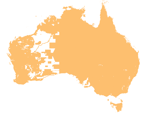
A detailed description of the coverage for each State and Territory is provided in the table below.
State or Territory Name |
State Abbreviation |
Coverage |
|---|---|---|
Australian Capital Territory |
ACT |
Complete coverage. |
New South Wales |
NSW |
Complete coverage. |
Northern Territory |
NT |
Complete coverage. |
Other Territories |
OT |
Christmas and Cocos (Keeling) Islands No Coverage. Jervis Bay No Coverage. Norfolk Island No Coverage. |
Queensland |
QLD |
State wide coverage. |
South Australia |
SA |
State wide coverage. |
Tasmania |
TAS |
State wide coverage. |
Victoria |
VIC |
Complete coverage. |
Western Australia |
WA |
Complete coverage. |
Delivery Format
Planning Insights is provided at the State/Territory level. The data is made available in PSV (Pipe Separated Values) file format.
PSV Files
Geopackage
Product Versioning
Planning Insights versioning is managed through incrementing when there is a change to the product schema or a significant change in data population, these are described further below:
A schema change can affect a major or minor increment to the versioning. Additive changes (changes that won’t break customers’ ability to work with the data) will be incremented with a minor version increment, an example is the addition of a new attribute. Removal of attributes or changing the structure of the Planning Insights schema will enact a major change to identify that this requires the attention of all customers and partners.
Where a significant geography of Australia either has a new population of data for an attribute or is populated from a much higher quality source a minor increment will be applied to the product version.
Therefore, Planning Insights versioning will not increment with every data update. Published releases will have a name e.g. ‘March 2023’ and will reference a version of the Planning Insights product e.g. ‘1.0’.