Overview
Planning Insights is a comprehensive representation of planning zone and overlay information applicable to land parcels and addresses across Australia. Planning Insights aims to provide insights to enable a greater understanding of how land can be developed and to inform about limitations and specific characteristics of planning sites.
Geoscape welcomes your feedback on the Planning Insights product. We also publish regular product development updates on our website ( www.geoscape.com.au ).
Release Summary
This product was released to customers on 30 June 2026 with data extracted on 19 June 2026.
Any issues that have been identified for this release are described in the Issues section.
Change Notifications
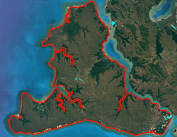
Hazard Overlay Update
A range of new hazard overlays have been introduced, covering features such as Acid Sulphate Soils, earthquake risk, and other environmental factors. These additions have led to an increase in records within the planning_insights_overlays table across NT, QLD, SA, TAS, VIC, and WA.
NSW Koala Overlay Reduction
Previously, in the NSW planning_insights_overlays table, our data supplier associated Koala overlays with any cadastre they spatially intersected. Following engagement with NSW councils, we have determined that only cadastral parcels above a certain size are applicable to this overlay.
As part of the June 2026 release, Koala overlay links have been removed for cadastral parcels that do not meet the minimum area requirement. This update has resulted in an approximate net reduction of 2.6 million records in the NSW planning_overlays table.
Consolidation of overlay_group values
Our data supplier has worked to consolidate overlay_group values for consistency in the planning_insights_overlays table. This change affects QLD (Conservation Area, Hazard), WA (Hazard, Mining), VIC (Hazard), TAS (Hazard) and NT (Hazard) overlay_group values.
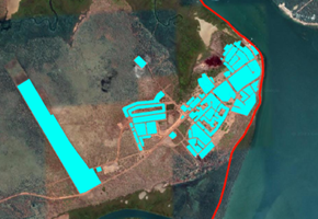
Ipswitch (QLD) Update
The June 2026 release includes an update to planning zone and overlay information within Ipswitch in QLD. This has resulted in significant zone code and name changes, as well as overlay updates (notably flood) in this region.
QLD and WA Industry and Infrastructure Overlay Update
For the June 2026 release, our data supplier has added new Industry overlays for QLD and WA, along with additional Infrastructure overlays for QLD. These updates have contributed to an increase in planning_insights_overlays records across these states.
Future Considerations
This section outlines enhancements or changes under consideration, but not planned into a specific release. For further details on future initiatives, please contact Geoscape Support.
New overlay_source attribute
Geoscape is investigating the inclusion of a new attribute called overlay_source, which would describe the source of the overlay in the planning_insights_overlays table.
This change will result in a minor increment to the product versioning from v1.0 to v1.1.
New zone_colour and zone_source attributes
Geoscape is investigating the inclusion of two new attributes called zone_colour and zone_source in the planning_insights_zoning table.
Zone Colour will provide a colour for each planning zone in hexadecimal format (e.g. ‘#A88484’), assigned on a scheme by scheme basis. Please be aware that this colour information is not consistent between planning schemes. For example, SA Commercial zones may have a different colour to NSW Commercial zones.
To assist in differentiating the planning schemas that provide the planning zone information, a Zone Source attribute will also be included that will provide the name of the zone source.
This change will result in a minor increment to the product versioning from v1.0 to v1.1.
Primary Zone Assignment Improvement
The planning_insights table currently provides a pi_zone_code attribute that provides a single zone code for a cadastre. Where a cadastre relates to multiple zones, a single zone code is consistently selected for the pi_zone_code.
We are investigating with our data provider the option of increasing the intelligence around this attribute so that it represents the planning zone with the largest area of overlap with the cadastre.