Wards
Disclaimer
Overview
Wards is a spatial representation of the gazetted ward districts, which are a subset of Local Government Area boundaries defined by State and Territory governments. Wards represent distinct areas within a local government area that relate to the election of councillors for the related local government. Wards aggregates the representations unique to each jurisdiction into a consistent seamless representation of the wards of Australia. Geoscape welcomes your feedback on the Wards product. We also publish regular product development updates on our website ( www.geoscape.com.au ).
Release Summary
This product was released to customers on 20 November 2023 with data extracted on 13 November 2023.
This release is a full national data population for Version 1.0 of the Wards product, described by Wards Product Guide v1.0.
Any issues that have been identified for this release are described in the Issues section.
Change Notifications
ESRI Shapefile width increase
Commencing with the February 2024 release, the width of numeric fields within Esri Shapefiles will increase by one. This is due to a bug fix in our packaging application. This change only impacts Shapefile metadata, the values and precision remain unchanged.
New data download portal
We’re pleased to announce the launch of our new customer collaboration portal called Geoscape Hub ( https://hub.geoscape.com.au ).
Geoscape Hub brings the experience for both our dataset and API customers together into one unified platform.
A notification announcing the launch of Geoscape Hub, with instructions on how to access and use the new portal, was sent out to data customers on 13 September. If you did not receive this important communication, please contact our Support team (support@geoscape.com.au).
From 13 September, all users navigating to the ‘Datasets’ page in geoscape.app have been redirected to Geoscape Hub.
Removal of the ‘Documents’ folder from data packages
From November 2023, Geoscape will be progressively moving product descriptions, guides and reports online to https://docs.geoscape.com.au
Commencing with the May 2024 release, data packages will no longer include the Documents folder.
Updates
New and Retired
New
ward_pid |
ward_name |
lga_pid |
state |
|---|---|---|---|
wad3_AsLjgZ5Zbv |
Ashburton - Tablelands Ward |
lga229c15cd02b0 |
WA |
wadmiJsGFoBUOGA |
Central Ward |
lga7d1ac9e6f9f2 |
WA |
wadpaCkNeoSsoRu |
Central Ward |
lgab3eac047a70e |
WA |
wadt2xCk1fW7geZ |
Coastal Ward |
lga7d1ac9e6f9f2 |
WA |
wadzdT9bnOeDzrg |
Rural Ward |
lga82fa96c43da5 |
WA |
wad7vWwDz9YpiSj |
Urban Ward |
lga82fa96c43da5 |
WA |
Retired
ward_pid |
ward_name |
lga_pid |
state |
|---|---|---|---|
wad528e1bdc2308 |
Ashburton Ward |
lga229c15cd02b0 |
WA |
wad1f2c28d707e3 |
Beaconsfield Ward |
lga7d1ac9e6f9f2 |
WA |
wade9e100941155 |
Benjinup Ward |
lga6865b59a3293 |
WA |
wadf30e6ec5107b |
Boyup Brook Ward |
lga6865b59a3293 |
WA |
wad1462c78162d3 |
Broome Ward |
lga3cd9f2694391 |
WA |
wadb19aab089370 |
Central Ward |
lga2e80b58b5711 |
WA |
wadf23dd498bb83 |
Central Ward |
lgab5f23977018c |
WA |
wadbe6e33c55b14 |
Central Ward |
lga82fa96c43da5 |
WA |
wadea2c21cae054 |
Central Ward |
lgaf1f600985d14 |
WA |
wad699e02a78800 |
Central Ward |
lgaa7208507e0f1 |
WA |
wad8f5b58ff3b88 |
City Ward |
lga7d1ac9e6f9f2 |
WA |
wadda2014644145 |
Coastal Ward |
lga82fa96c43da5 |
WA |
wada9e54201c109 |
Dampier Ward |
lga3cd9f2694391 |
WA |
wad10a4227337c3 |
Dampier Ward |
lga12712c7fbac0 |
WA |
wad2b55108893ef |
Dinninup Ward |
lga6865b59a3293 |
WA |
wad8cfed39baac8 |
East Ward |
lga82fa96c43da5 |
WA |
wad690980516346 |
East Ward |
lga2e80b58b5711 |
WA |
wad29a480cac882 |
East Ward |
lgab5f23977018c |
WA |
wad697779d2f664 |
East Ward |
lga19a8033e8309 |
WA |
wad58678e3561b6 |
Hilton Ward |
lga7d1ac9e6f9f2 |
WA |
wad144cef9abdae |
Kalbarri Ward |
lga04147236faf8 |
WA |
wad7ce36ccea80a |
Karratha Ward |
lga12712c7fbac0 |
WA |
wad29c951422d66 |
Lower Central Ward |
lgaa7208507e0f1 |
WA |
wadb278f72f1876 |
North Ward |
lga82fa96c43da5 |
WA |
wada9dae77ed871 |
North Ward |
lgaf1f600985d14 |
WA |
wadfee6144f7113 |
North West Ward |
lgaa7208507e0f1 |
WA |
wad9544a21e2182 |
Northampton Ward |
lga04147236faf8 |
WA |
wad3cf07ad2c763 |
Scotts Brook Ward |
lga6865b59a3293 |
WA |
wad8d57ef3f9b2c |
South Ward |
lgaf1f600985d14 |
WA |
wad63e2c122a444 |
South Ward |
lga2e80b58b5711 |
WA |
wad169fa96ed716 |
South Ward |
lga19a8033e8309 |
WA |
wad9cbe22f3ba39 |
South Ward |
lga82fa96c43da5 |
WA |
wadb43a95622be5 |
South Ward |
lga7d1ac9e6f9f2 |
WA |
wad1a9dde5c1c47 |
Tableland Ward |
lga229c15cd02b0 |
WA |
wade26d529faf75 |
Town Ward |
lgab5f23977018c |
WA |
wad4b1df8067cd4 |
Town Ward |
lgabbf72d87e377 |
WA |
wadb8c78e940ab4 |
West Ward |
lgab5f23977018c |
WA |
wad58f95596f9c3 |
West Ward |
lga82fa96c43da5 |
WA |
wad8d04e820b656 |
West Ward |
lga19a8033e8309 |
WA |
wad3fa4adc60be2 |
West Ward |
lga2e80b58b5711 |
WA |
wad30871570a1e7 |
Wickham - Point Samson - Roebourne - Cossack - Pastoral Ward |
lga12712c7fbac0 |
WA |
Spatial Changes
Spatial changes (area) greater than 1 km2 are shown below:
ward_pid |
ward_name |
state |
Difference SQKM |
Old SQKM |
New SQKM |
|---|---|---|---|---|---|
wad3fee6ca70f34 |
North Ward |
WA |
52079 |
25,035 |
77,114 |
wad0459edde0213 |
East Ward |
WA |
228 |
752 |
980 |
wadc067c582b426 |
West Ward |
WA |
24 |
295 |
319 |
wadbe65207aa73d |
Rural Ward |
WA |
21 |
53,713 |
53,734 |
wad0dbddf82c31f |
Whiteman Ward |
WA |
15 |
69 |
84 |
wad9d9b60e813ff |
Midland / Guildford Ward |
WA |
4 |
46 |
50 |
wad436506337bd0 |
Altone Ward |
WA |
3 |
18 |
21 |
wad913580569dd4 |
East Ward |
WA |
3 |
20 |
23 |
wad3b346fb6554b |
South East Ward |
WA |
3 |
13 |
16 |
wadcb8c893e7b96 |
South Ward |
WA |
3 |
12 |
15 |
wad613843b9769b |
Town Ward |
WA |
3 |
15 |
18 |
wadf4fbe7d4a395 |
East Ward |
WA |
2 |
3 |
5 |
wada2d4edb0fa33 |
North Ward |
WA |
2 |
4 |
6 |
wad69556b6cc522 |
North Ward |
WA |
2 |
24 |
26 |
wad75255d5b076d |
North West Ward |
WA |
-2 |
14 |
12 |
wad85830dcfeb8f |
South Ward |
WA |
-2 |
11 |
9 |
wad046696c9b6ee |
North Ward |
WA |
-3 |
23 |
20 |
wad1478008c32e4 |
South West Ward |
WA |
-3 |
16 |
13 |
wad51157bb49336 |
West Ward |
WA |
-5 |
8 |
3 |
wadd9fd1466285f |
North Ward |
WA |
-6 |
31 |
25 |
wadc5c9bfca3e18 |
Pearce Ward |
WA |
-21 |
377 |
356 |
wad34da53cd7ae1 |
Town Ward |
WA |
-21 |
43 |
22 |
wad10dfbf6a8d09 |
Coastal Ward |
WA |
-44 |
154 |
110 |
wad32ae80bbacba |
Central Ward |
WA |
-225 |
358 |
133 |
Other Updates
There were no other updates.
Issues
New Issues
No new issues.
Resolved Issues
No resolved issues to note.
Known Issues
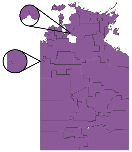
Un-enclosed gaps between Wards in NT
There are two un-enclosed gaps present in the Wards data in NT. These gaps are not valid and do not represent rivers. Below, the un-enclosed gaps can be seen between polygons when they are dissolved together.
SA coastline generalisation for Central Ward
Jurisdictional changes to the coastline geometry have resulted in polygon generalisation for ‘Central Ward’ Ward in South Australia. These changes are related to boundary changes made to ‘The DC of Grant’ LGA. This has reduced the number of vertices in the polygons resulting in geometry differences and, in some scenarios, the creation of additional polygons for the LGA. Below is an example where a previous Admin Boundaries LGA outline (blue) can be seen compared to the new Local Government Area product representation (red area).
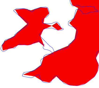
Geoscape is currently investigating this generalisation with the SA jurisdiction.
Future Considerations
This section outlines enhancements or changes under consideration, but not planned into a specific release. For further details on future initiatives, please contact Geoscape Support.
Annex A – Release Counts
Additional, retired and total Wards counts and the percent change to the previous release have been listed in the table below.
TABLE NAME |
ACT |
NSW |
NT |
OT |
QLD |
SA |
TAS |
VIC |
WA |
TOTAL |
|
|---|---|---|---|---|---|---|---|---|---|---|---|
wards |
Additional |
0 |
0 |
0 |
0 |
0 |
114 |
0 |
0 |
109 |
223 |
Retired |
0 |
0 |
0 |
0 |
0 |
114 |
0 |
0 |
120 |
234 |
|
Updated |
0 |
0 |
0 |
0 |
0 |
0 |
0 |
0 |
0 |
0 |
|
Total |
0 |
0 |
829 |
0 |
0 |
155 |
0 |
313 |
226 |
1,523 |
|
% Change |
0.00% |
0.00% |
0.00% |
0.00% |
0.00% |
0.00% |
0.00% |
0.00% |
-4.64% |
-0.72% |