Localities
Disclaimer
Introduction
Localities is a spatial representation of suburbs and localities defined by the State and Territory governments of Australia. Localities aggregates the representations unique to each jurisdiction into a consistent seamless representation of the suburbs and localities of Australia. Geoscape welcomes your feedback on the Localities product. We also publish regular product development updates on our website ( www.geoscape.com.au ).
Document Purpose
This document provides a description of the issues, changes, features, updates and statistics relating to the applicable Localities release. This document should be read in conjunction with the current Localities Product Guide.
References
Localities Product Guide Version 1.0 Geoscape Data ( www.geoscape.com.au/data/administrative-boundaries/ )
Contact
Overview
Release Summary
This product was released to customers on 20 November 2023 with data extracted on 29 September 2023.
This release is a full national data population for Version 1.0 of the Localities product, described by the Localities Product Guide v1.0.
Any issues that have been identified for this release are described in the Issues section.
Change Notifications
ESRI Shapefile width increase
Commencing with the February 2024 release, the width of numeric fields within Esri Shapefiles will increase by one. This is due to a bug fix in our packaging application. This change only impacts Shapefile metadata, the values and precision remain unchanged.
New data download portal
We’re pleased to announce the launch of our new customer collaboration portal called Geoscape Hub ( https://hub.geoscape.com.au ).
Geoscape Hub brings the experience for both our dataset and API customers together into one unified platform.
A notification announcing the launch of Geoscape Hub, with instructions on how to access and use the new portal, was sent out to data customers on 13 September. If you did not receive this important communication, please contact our Support team (support@geoscape.com.au).
From 13 September, all users navigating to the ‘Datasets’ page in geoscape.app have been redirected to Geoscape Hub.
Removal of the ‘Documents’ folder from data packages
From November 2023, Geoscape will be progressively moving product descriptions, guides and reports online to https://docs.geoscape.com.au
Commencing with the May 2024 release, data packages will no longer include the Documents folder.
Updates
New and Retired
- 1 locality has been retired in NSW:
Back Creek (locality_pid = ‘loc365c9229b366’). The area of this locality was amalgamated into the locality of Mongarlowe (locality_pid ‘loc1db45efffad9’).
The locality of Balmoral (locality_pid = ‘loc11112536618e’) has had a name change to ‘Balmoral Village’. This name change has been applied by the jurisdiction to differentiate two localities in NSW that previously had the same name of ‘Balmoral’. The locality_pid for this locality has been retained.
Spatial Changes
Spatial changes (area) greater than 1 km2 are shown below:
locality_pid |
locality_name |
state |
Difference (km2) |
Old (km2) |
New (km2) |
|---|---|---|---|---|---|
loc7335597ec06b |
Gurindji |
NT |
7,250 |
32,383 |
39,633 |
loc7a211879023a |
Alpha |
QLD |
389 |
12,213 |
12,602 |
loc7da2e90022aa |
Laglan |
QLD |
150 |
3,020 |
3,170 |
loc762c29a48434 |
Hawkwood |
QLD |
51 |
1,186 |
1,237 |
locc7564e4ad96d |
Keera |
NSW |
45 |
318 |
363 |
locdb8620eee890 |
Blackall |
QLD |
44 |
16,557 |
16,601 |
loc1db45efffad9 |
Mongarlowe |
NSW |
40 |
35 |
75 |
loce4e670f7e6e6 |
Torrens Creek |
QLD |
29 |
6,077 |
6,106 |
loc33f8ee3bf8da |
Aramac |
QLD |
28 |
15,220 |
15,248 |
loc6b745fb4c112 |
Muttaburra |
QLD |
24 |
6,289 |
6,313 |
loc1ecc8fee2ed1 |
Boggabilla |
NSW |
17 |
1,355 |
1,372 |
loc4ca9d6f6c8fd |
Pallamallawa |
NSW |
17 |
497 |
514 |
locfa3a3309275c |
Clermont |
QLD |
14 |
5,145 |
5,159 |
locbffbb22afe81 |
Yallaroi |
NSW |
14 |
261 |
275 |
loc2a274dcc84f4 |
Ilfracombe |
QLD |
10 |
6,574 |
6,584 |
loc0ac67daeeaa2 |
Kimbolton |
WA |
8 |
6,906 |
6,914 |
loce4f495301f73 |
Balfours Peak |
NSW |
5 |
122 |
127 |
loc455bbf2f3ebf |
Dinoga |
NSW |
4 |
305 |
309 |
loc0f6834982039 |
Willows |
QLD |
4 |
1,210 |
1,214 |
loc0a4dd2078c83 |
Calliope |
QLD |
3 |
183 |
186 |
locd0101180284c |
Carnarvon Park |
QLD |
3 |
2,392 |
2,395 |
loc03c2ec5dcf24 |
Mantuan Downs |
QLD |
3 |
2,412 |
2,415 |
locb297a954603e |
Tanami East |
NT |
2 |
52,844 |
52,846 |
locb18b44e7be76 |
Glenning Valley |
NSW |
1 |
6 |
7 |
loc520848f8eea4 |
Berkeley Vale |
NSW |
-1 |
6 |
5 |
loc2189d52b1f00 |
Buckland |
QLD |
-1 |
1,771 |
1,770 |
loc8671a7a4310d |
Nandowrie |
QLD |
-1 |
697 |
696 |
locabf3176ecfa2 |
Elgin |
QLD |
-2 |
2,340 |
2,338 |
locb04d6671751d |
Peak Vale |
QLD |
-2 |
819 |
817 |
loc53be93fc501d |
Coffin Bay |
SA |
-3 |
361 |
358 |
locd7e01f411266 |
Talandji |
WA |
-3 |
5,705 |
5,702 |
loca0f7a755c487 |
Cobbadah |
NSW |
-4 |
245 |
241 |
loc7e95f1561f01 |
Wooderson |
QLD |
-4 |
296 |
292 |
loc701d68a6c6d0 |
Delungra |
NSW |
-5 |
663 |
658 |
locf5b5670c1f64 |
Barcaldine |
QLD |
-10 |
10,012 |
10,002 |
loc3808fea12be5 |
Blue Nobby |
NSW |
-13 |
124 |
111 |
loc89aba4ec79e1 |
Tulloona |
NSW |
-16 |
363 |
347 |
loc353c764ec3ee |
Crooble |
NSW |
-17 |
240 |
223 |
loc8278f742b227 |
Exmouth Gulf |
WA |
-19 |
4,928 |
4,909 |
locb15f4b77277d |
Gulf Creek |
NSW |
-20 |
176 |
156 |
locb8bc91c4b9c7 |
Longreach |
QLD |
-25 |
23,495 |
23,470 |
locb40e996092da |
Bundarra |
NSW |
-26 |
995 |
969 |
loc0015d417b77d |
Lochington |
QLD |
-46 |
4,456 |
4,410 |
loc9fa84ede0382 |
Cheltenham |
QLD |
-51 |
446 |
395 |
loc13104c56055a |
Pentland |
QLD |
-57 |
14,977 |
14,920 |
loc338646445555 |
Quetta |
QLD |
-177 |
1,301 |
1,124 |
loc8139ce942ef2 |
Jericho |
QLD |
-378 |
9,648 |
9,270 |
loc93a1abde8231 |
Lajamanu |
NT |
-7,250 |
7,258 |
8 |
Other Updates
There were no other updates.
Issues
New Issues
No new issues.
Resolved Issues
No resolved issues to note.
Known Issues
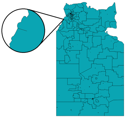
Un-enclosed gap between Localities in NT
There is one un-enclosed gap present in the Localities data in NT. These gaps are not valid and do not represent rivers. Below, the un-enclosed gaps can be seen between polygons when they are dissolved together.
ACT Localities Geodatabase File Name Issue
There is a known issue with QGIS reading the act_localities geodatabase file. This issue is related to the file name, so simply changing it (e.g. to ‘act_locality.gdb’) will allow it to be opened in QGIS.
Future Considerations
This section outlines enhancements or changes under consideration, but not planned into a specific release. For further details on future initiatives, please contact Geoscape Support.
Annex A – Release Counts
Additional, retired and total Localities counts and the percent change to the previous release have been listed in the table below.
TABLE NAME |
ACT |
NSW |
NT |
OT |
QLD |
SA |
TAS |
VIC |
WA |
TOTAL |
|
|---|---|---|---|---|---|---|---|---|---|---|---|
localities |
Additional |
0 |
342 |
10 |
0 |
243 |
786 |
28 |
0 |
306 |
1,715 |
Retired |
0 |
343 |
10 |
0 |
243 |
786 |
28 |
0 |
306 |
1,716 |
|
Updated |
0 |
0 |
0 |
0 |
0 |
0 |
0 |
0 |
0 |
0 |
|
Total |
140 |
4,606 |
312 |
6 |
3,305 |
1,897 |
783 |
2,973 |
1,752 |
15,774 |
|
% Change |
0.00% |
-0.02% |
0.00% |
0.00% |
0.00% |
0.00% |
0.00% |
0.00% |
0.00% |
-0.01% |