Technical Description
Planning is created through the spatial intersection of Cadastre cadastral polygon centroids with planning zone spatial boundaries. Through this process, a planning zone code and its associated descriptive information are associated with a cadastral polygon. In areas where State and local Government planning zone sources are both used to build the dataset, and these overlap one another, the local Government source has been prioritised for the relationship.
All non-Road Cadastre polygons are utilised in the assignment process, inclusive of all parcel_status values.
Planning is created from a range of State, Territory and local Government data which is revised regularly and supplied in varying formats and levels of quality. Planning zone code values for these source datasets differ greatly across jurisdictions and local governments due to unique planning regulations between States and also between Local Government Areas (LGAs). A ‘psma_description’ attribute has been included for each planning record to serve as a general description of the planning zone codes across Australia and ease understanding of the data at a national level. Planning zone codes are not necessarily unique across Australia or by LGA.
Planning uses a process of spatial intersection at the centroid of a parcel and in the case of overlapping planning zones chooses a single planning zone classification. Therefore, it is not suitable for uses that require definitive planning information. In such cases, users should contact the relevant State, Territory or local Government planning authority for authoritative planning scheme information.
Geoscape Australia welcomes your feedback on the Planning product. We also publish regular updates on the development of our products on the Geoscape website ( www.geoscape.com.au ).
Attributes
Zone Code
The Zone Code is the code related to the planning zone provided by each jurisdiction or council. The Zone Code is related to the cadastral polygon that intersects with the supplied planning zone polygon. In areas where data was supplied by a local Government this was prioritised over a supply from the State government.
Primary Zone Description
The Primary Zone Description is directly related to the Zone Code and informs about the meaning of the code. This description can be used as a brief explanation of the planning zone or planning zone use that is related to the cadastral polygon.
Where the Zone Code is supplied as a description the Primary Zone Description may be the same as the Zone Code.
Secondary Zone Description
The Secondary Zone Description can give further information on the planning zone or planning zone use related to the cadastral polygon. Generally, this describes what is currently built or planned to be developed within the planning zone.
PSMA Description
The PSMA Description gives a generalised description used by Geoscape Australia for the Zone Code assigned to a cadastral polygon. This information was created by Geoscape Australia to provide a nationally consistent description of the planning zones across Australia.
Source
The Source provides the name of the State or local Government authority that the planning data was sourced from.
URL
The URL attribute provides a direct link to the planning website of the State or local Government that the planning zone data was sourced from. This URL can be used to access further information and detailed descriptions about the planning zone codes directly from each jurisdiction.
Data Dictionary
planning
Attribute |
Data Type |
Description |
Primary Key |
Mandatory Field |
Foreign Key Table |
Foreign Key Column |
10 Character Alias |
|---|
cad_polygon_pid |
Character String (15) |
The persistent identifier for the Cadastre record* that is spatially related to the planning zone. |
Yes |
Yes |
cadastre |
cadastre_polygon_pid |
CD_PLY_PID |
cad_pid |
Character String (15) |
The unique persistent identifier for each Cadastre record* that is spatially related to the planning zone. |
Yes |
Yes |
cadastre |
cadastre_pid |
CAD_PID |
date_created |
Date |
The date that the planning-cadastre relationship has been created. |
No |
Yes |
|
|
DT_CREATE |
state |
Character String (3) |
The abbreviated name of the State or Territory related to the Planning Zone data. |
No |
Yes |
|
|
STATE |
zone_code |
Character String (90) |
The detailed planning zone code provided by the jurisdiction or council that is related to the cadastral polygon. |
No |
Yes |
|
|
ZONE_CODE |
primary_zone_description |
Character String (100) |
Descriptive information about the planning zone or planning zone use that is related to the cadastral polygon. |
No |
Yes |
|
|
ZN_DESC_1 |
secondary_zone_description |
Character String (350) |
Ancillary descriptive information about the planning zone or planning zone use that is related to the cadastral polygon. |
No |
No |
|
|
ZN_DESC_2 |
psma_description |
Character String (30) |
The generalised planning zone description used by Geoscape Australia for the assigned planning zone. |
No |
No |
|
|
PSMA_DESC |
source |
Character String (40) |
The State or local Government source of the planning data. |
No |
Yes |
|
|
SOURCE |
url |
Character String (125) |
The web address location of the planning instrument or scheme relating to the associated planning zone information. |
No |
Yes |
|
|
URL |
Domain Values
psma_description
Domain Value |
Description |
|---|
COMMERCIAL/BUSINESS |
Areas where the state, territory or local government planning scheme generally indicate a commercial or business focus. |
COMMUNITY USE |
Areas where the state, territory or local government planning scheme generally indicate community use. |
CONSERVATION/NATIONAL PARK |
Areas where the state, territory or local government planning scheme generally indicate National Park or a conservation requirement. |
INDUSTRIAL/UTILITIES |
Areas where the state, territory or local government planning scheme generally indicate industrial activities and/or utility facilities. |
MIXED USE |
Areas where the state, territory or local government planning scheme generally indicate mixed use. |
RECREATIONAL/OPEN SPACE |
Areas where the state, territory or local government planning scheme generally indicate recreational activities and/or open space. |
RESIDENTIAL |
Areas where the state, territory or local government planning scheme generally indicate residential. |
RURAL/PRIMARY PRODUCTION |
Areas where the state, territory or local government planning scheme generally indicate rural and/or primary production activities. |
SPECIAL USE |
Areas where the state, territory or local government planning scheme generally indicate special use. |
TRANSPORT/INFRASTRUCTURE |
Areas where the state, territory or local government planning scheme generally indicate transport and/or other infrastructure. |
WATER |
Areas where the state, territory or local government planning scheme generally indicate waterways or other water areas. |
<NULL> |
Areas where the state, territory or local government planning scheme does not generally indicate one of the above classes. |
Update Frequency
Planning is released on a quarterly schedule against the latest Cadastre data, with planning data updated bi-annually.
Planning Release Month |
Cadastre Release Month used in Planning |
Planning Zone Source Data Cut-off Month used in Planning |
|---|
March |
February |
February |
June |
May |
February |
September |
August |
August |
December |
November |
August |
Extent/Geographic Description
Planning is an aspatial dataset and therefore has no spatial coverage unless joined to Cadastre. Once joined to Cadastre, Planning has spatial coverage across all States and Territories. Planning information may not be available for land held by the Commonwealth, as this land is not managed by State or local Government authorities.
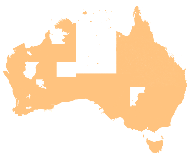
A detailed description of the coverage for each State and Territory is provided in the table below.
State or Territory Name |
State (Abbreviation) |
Coverage |
|---|
Australian Capital Territory |
ACT |
Complete coverage. |
New South Wales |
NSW |
State wide coverage. The north-western corner of the State is not included due to a lack of planning data available in this area. |
Northern Territory |
NT |
Coverage of major urban centres and towns (Darwin, Alice Springs, etc.). Coverage of the remainder of the State is not included due to lack of available planning data in these areas. |
Other Territories |
OT |
Cocos (Keeling) Islands and Christmas Island are included.
Jervis Bay and Norfolk Island are not included due to lack of available planning data in these areas. |
Queensland |
QLD |
State wide coverage. There are a small number of areas where planning data is unavailable, mostly on the northern peninsula of the State.
State-sourced planning data for Queensland was last updated in 2010 and is no longer maintained. For this reason, planning data has also been sourced from local Government sources with significant population for:
Brisbane City Council Bundaberg Regional Council Burdekin Shire Council Cairns Regional Council City of Gold Coast City of Ipswich City of Townsville Fraser Coast Regional Council Lockyer Valley Regional Council Logan City Council Mareeba Shire Council Moreton Bay Regional Council Noosa Council Redland City Council Sunshine Coast Council Toowoomba Regional Council
For all other areas across Queensland state-sourced planning data is used where available.
Local Government planning data has been prioritised where there is an overlap with State sourced data.
|
South Australia |
SA |
State wide coverage. |
Tasmania |
TAS |
State wide coverage. |
Victoria |
VIC |
Complete coverage. |
Western Australia |
WA |
Coverage of major urban centres and towns, as well as most rural areas. Coverage in eastern rural areas and national parks are not included due to lack of available planning data in these areas. |
Product Versioning
Planning versioning is managed through incrementing when there is a change to the product schema or a significant change in data population, these are described further below:
A schema change can affect a major or minor increment to the versioning. Additive changes (changes that won’t break customers’ ability to work with the data) will be incremented with a minor version increment, an example is the addition of a new attribute. Removal of attributes or changing the structure of the Planning schema will enact a major change to identify that this requires the attention of all customers and partners.
Where a significant geography of Australia either has a new population of data for an attribute or is populated from a much higher quality source a minor increment will be applied to the product version.
Therefore, Planning versioning will not increment with every data update, published releases will have a name e.g. ‘June 2020’ and will reference a version of the Planning product e.g. ‘1.1’.
![digraph G {
graph [pad="0.5", ranksep="1"];
fontname="ROBOTO" fontsize="10pt"
node [fontname="ROBOTO" fontsize="8pt"]
edge [fontname="ROBOTO" fontsize="8pt"]
rankdir=LR
subgraph cluster_planning { label="Geoscape Planning"
graph[style="dashed,rounded" color="#EA6B66"]
planning [shape=plain
label=<<TABLE BGCOLOR="#FFD966"
BORDER="1"
CELLBORDER="0"
style="rounded"
CELLSPACING="0"
CELLPADDING="5">
<TR>
<TD COLSPAN="2">planning</TD>
</TR>
<TR>
<TD BGCOLOR="white" >PK</TD>
<TD BGCOLOR="white" ALIGN="LEFT" >cad_polygon_pid: varchar (15) </TD>
</TR>
<TR>
<TD BGCOLOR="white" >PK</TD>
<TD BGCOLOR="white" ALIGN="LEFT" >cad_pid: varchar (15) </TD>
</TR>
<TR>
<TD BGCOLOR="white" ></TD>
<TD BGCOLOR="white" ALIGN="LEFT" >date_created: date </TD>
</TR>
<TR>
<TD BGCOLOR="white" ></TD>
<TD BGCOLOR="white" ALIGN="LEFT" >state: varchar (3) </TD>
</TR>
<TR>
<TD BGCOLOR="white" ></TD>
<TD BGCOLOR="white" ALIGN="LEFT" >zone_code: varchar (90) </TD>
</TR>
<TR>
<TD BGCOLOR="white" ></TD>
<TD BGCOLOR="white" ALIGN="LEFT" >primary_zone_description: varchar (100) </TD>
</TR>
<TR>
<TD BGCOLOR="white" ></TD>
<TD BGCOLOR="white" ALIGN="LEFT" >secondary_zone_description: varchar (350) </TD>
</TR>
<TR>
<TD BGCOLOR="white" ></TD>
<TD BGCOLOR="white" ALIGN="LEFT" >psma_description: varchar (30) </TD>
</TR>
<TR>
<TD BGCOLOR="white" ></TD>
<TD BGCOLOR="white" ALIGN="LEFT" >source: varchar (40) </TD>
</TR>
<TR>
<TD BGCOLOR="white" ></TD>
<TD BGCOLOR="white" ALIGN="LEFT" >url: varchar (125) </TD>
</TR>
</TABLE>>];
}
cadastre [ style=filled shape=Mrecord fillcolor="#7EA6E0" ]
cadastre -> planning [arrowhead=noneteenoneodot dir=both arrowtail=nonetee]
subgraph cluster_legend {
graph[style="" label="Legend" ]
legend [shape=plain
label=<<TABLE
CELLBORDER="0"
Border="0">
<TR>
<TD BGCOLOR="#7EA6E0" BORDER="1"> </TD>
<TD>Spatial Attribute Table</TD>
</TR>
<TR>
<TD BGCOLOR="#FFD966" BORDER="1"> </TD>
<TD>Textual Attribute Table</TD>
</TR>
</TABLE>>]
key [shape=plain label=<<table border="0" cellpadding="1" cellspacing="0" cellborder="0">
<tr><td port="i1"> Zero or One </td> </tr>
<tr><td port="i2"> One </td> </tr>
</table>>]
key2 [shape=plain label=<<TABLE border="0" cellpadding="1" cellspacing="0" CELLBORDER="0">
<tr><td port="i1"> </td></tr>
<tr><td port="i2"> </td></tr>
</TABLE>>]
key:i1 -> key2:i1 [arrowhead=noneteenoneodot]
key:i2 -> key2:i2 [arrowhead=nonetee]
}
planning -> legend [style=invis]
}](_images/graphviz-655fa4463e1c48b5d24867e1736fceda3fb53027.png)