Annex A - User Guide
Strata counts and what they represent
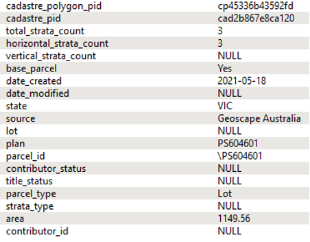
The total_strata_count, vertical_strata_count and horizontal_strata_count attributes populated for base Lot parcels (base_parcel = 'Yes') can be used to easily access the count of strata parcels at a site and can give insight into the vertical or horizontal distribution of strata at the site.
Where Geoscape Australia is able to classify Strata parcels as vertical or horizontal, this information will be available as a vertical or horizontal strata count on the base Lot parcel.
Examples of strata count representations are shown below.
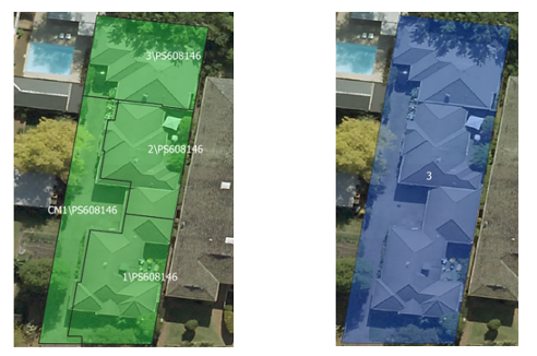
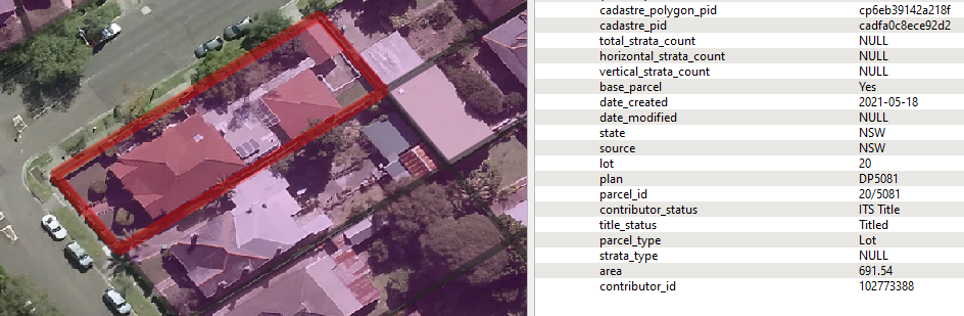
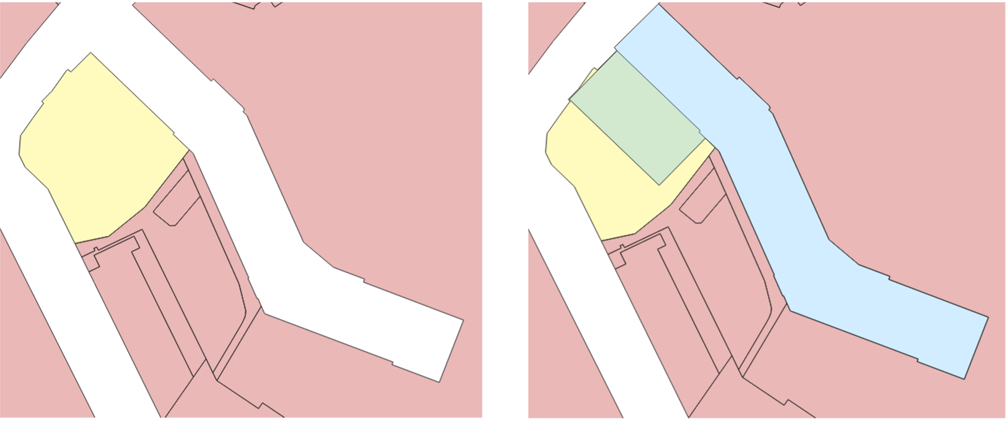
Example 1
Victoria: 145.0362041845, -37.7688367440.
In the below image on the left, the parcel_ids (white text) show that the strata parcels represent different lots on the same plan (PS608146), but no Lot parcel has been provided by the jurisdiction.
A Geoscape Australia source parcel has been created to represent the Lot parcel at this site (the image on the right) as a dissolved polygon created from the 4 strata parcels, with the total_strata_count value of '3' shown in white text. The common property strata parcel (lot = 'CM1') has not been counted.
At this site the four strata parcels have a strata_type value of 'Horizontal'. This means that the Lot parcel related to them will have a horizontal_strata_count of '3'. The vertical_strata_count will be null here as there are no vertical strata parcels present on the plan.
Horizontal Strata count example with © Aerometrex Ltd Aerial Imagery [Aerometrex, 2023].
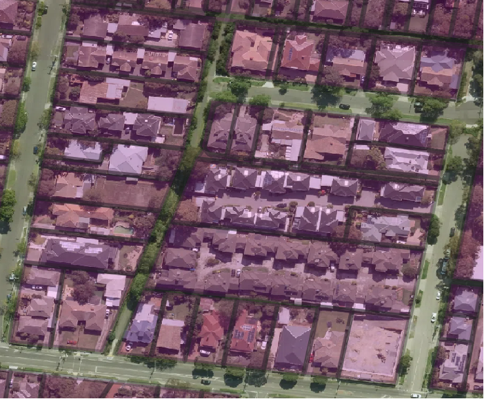
Example 2
The below image shows only the base layer with the total strata counts labelled in white text.
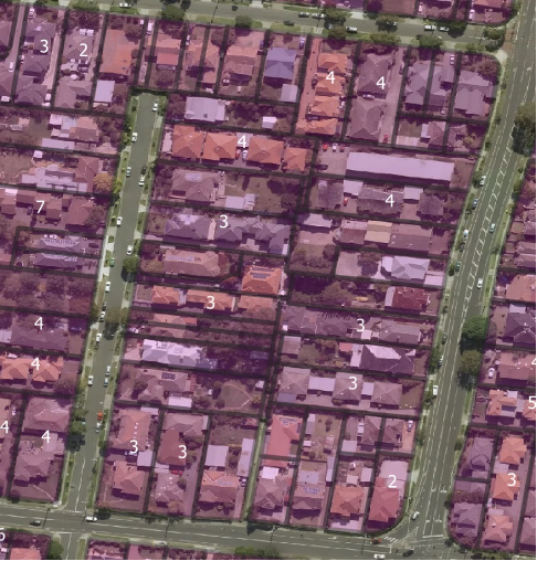
Total Strata counts with © Aerometrex Ltd Aerial Imagery [Aerometrex, 2023].
Example 3
Western Australia: 115.878985815, -31.987057060
The jurisdiction can provide Lot parcels at locations where Strata parcels exist with a different plan. This can be seen here where there are two Strata parcels with plan of ‘S009789’ present that overlap a Lot parcel with plan of ‘D042602’. At sites such as these, the strata counts have been assigned to the base Lot parcel that already exists at the site.
Here the total_strata_count and horizontal_strata_count will be ‘2’ for the base Lot parcel as the Strata parcels have a strata_type of ‘Horizontal’.
Strata parcels do not always accurately describe the area or boundary of the title related to the Strata. Below is an image of the WA site described above. It is visible that all the horizontal Strata parcels have the same geometry at the site, and the individual dwellings are not defined by the two strata boundaries below (green polygons), which have the same geometry. This will occur in cadastre where the jurisdictional data does not provide information that allows distinct polygon representation for Strata parcels and can also occur for vertical strata.
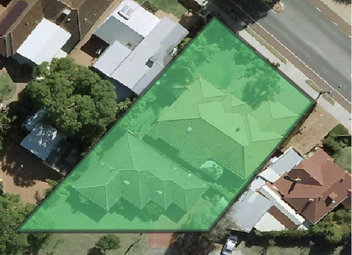
Horizontal strata with identical geometry shown with © Aerometrex Ltd Aerial Imagery [Aerometrex, 2023].
Example 4
Australian Capital Territory: 149.1070277, -35.3135129
Vertical strata polygons do not exist in the ACT’s jurisdictional data. However, we are able to describe the vertical_strata_count for base Lot parcels that relate to vertical strata due to aspatial data provided by the jurisdiction. In the ACT, we are unable to create vertical Strata parcels as the aspatial data does not provide unit numbers that we could use to differentiate the vertical strata parcels.
This can be seen here where there is a Lot parcel that relates to vertical strata (i.e. the units at the site are arranged in a vertical structure). No vertical Strata parcels exist in the jurisdictional data, but the base Lot parcel with parcel_id = 'CANB/DEAK/12/20' will be assigned a vertical_strata_count of ‘114’ through aspatial information provided by the jurisdiction.
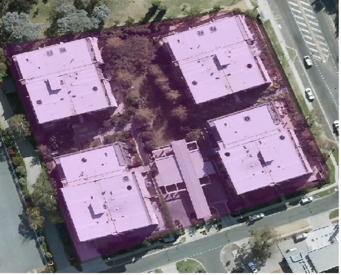
ACT aspatial vertical strata count example with © Aerometrex Ltd Aerial Imagery [Aerometrex, 2023].
Parcel IDs and how to search Land Registries
The parcel_id can be used to directly look up a cadastre record in the State or Territory land registry.
Some jurisdictions allow you to search the parcel_id as it exists in the product, while for some states, parcel_ids cannot be directly input into a land registry and must be split apart into its lot and plan components. Where the latter is the case, the parcel_id will have forward slashes present to split the values and make it easier to search for the parcel.
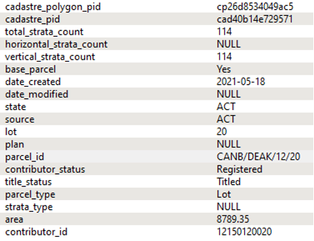
Example 1
An example for NSW can be seen at 151.21655356, -33.90774711 in NSW, where a Lot parcel has a parcel_id of '20/5081' (see selected polygon below with attribution).
NSW parcel_id lookup example © Aerometrex Ltd Aerial Imagery [Aerometrex, 2023].
The current land registry for NSW can be located at: https://online.nswlrs.com.au/wps/portal/six/find-records/.
The parcel_id of '20/5081' can be directly input into the ‘Search location records’ dialogue box in the land registry to search for the cadastral parcel. Doing this will return a result in the form of imagery, showing the location of the cadastre, as well as ‘Prior title search’ and ‘Land value search’ options to the left of the screen.
The ‘View’ button next to the ‘Prior title search’ result can be used to access the prior title reference of '13158-127'. This title reference can be used to access more information about the parcel.
Example 2
In Victoria, the parcel_id can also be directly input into the land registry.
An example of this can be seen at 144.81306361, -37.79130841 where there are seven Strata parcels present. They have parcel_ids of 'CM\RP3294', '1\RP3294', '2\RP3294', … and '6\RP3294'.
These parcel_ids can be searched in the Victorian land registry at: https://www.land.vic.gov.au/property-and-parcel-search. For example, when the parcel_id of '1\RP3294' is input into the search field and searched, additional information about the parcel is provided.
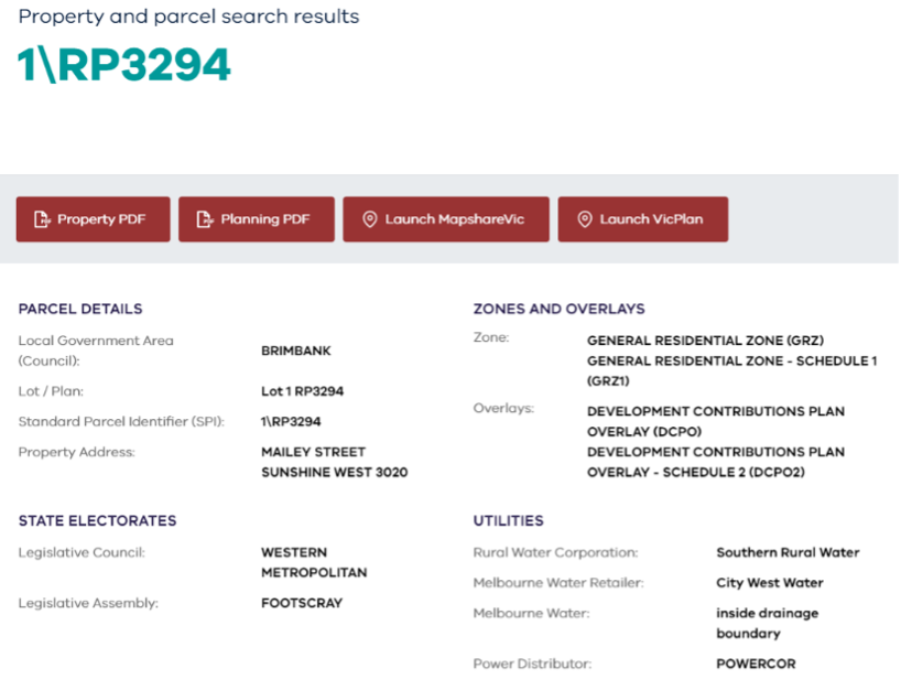
Screenshot taken from Victorian land registry website © State Government of Victoria [Department of Environment, Land, Water and Planning, 2023]. Available under CC BY 4.0 licence.
Example 3
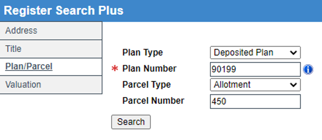
In South Australia at 138.5747180, -33.7118605 the parcel has a parcel_id of 'D/90199/A/450'. Here, the forward slashes separate 'Plan Type', 'Plan Number', 'Parcel Type' and 'Parcel Number' information that must be individually input into the land registry to search for the parcel.
The land registry for SA (SAILIS) can be found at: https://sailis.lssa.com.au/products/titleSearch/registerSearchPlus?form.
To search, click the 'Plan/Parcel' tab to the left of the screen. This will prompt you with four search boxes relating to the parts of the parcel_id. The search for the parcel_id of 'D/90199/A/450' would be done as shown below.
Screenshot taken from SAILIS website © [Land Services SA, 2023], © South Australian Government.
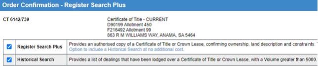
This will return information about the parcel, as well as the ability to order a copy of the certificate of title.
Screenshot taken from SAILIS website © [Land Services SA, 2023], © South Australian Government.
Note
Road parcels are generally not searchable in the land registries. Parcels with source = 'Geoscape Australia' will also not be searchable.
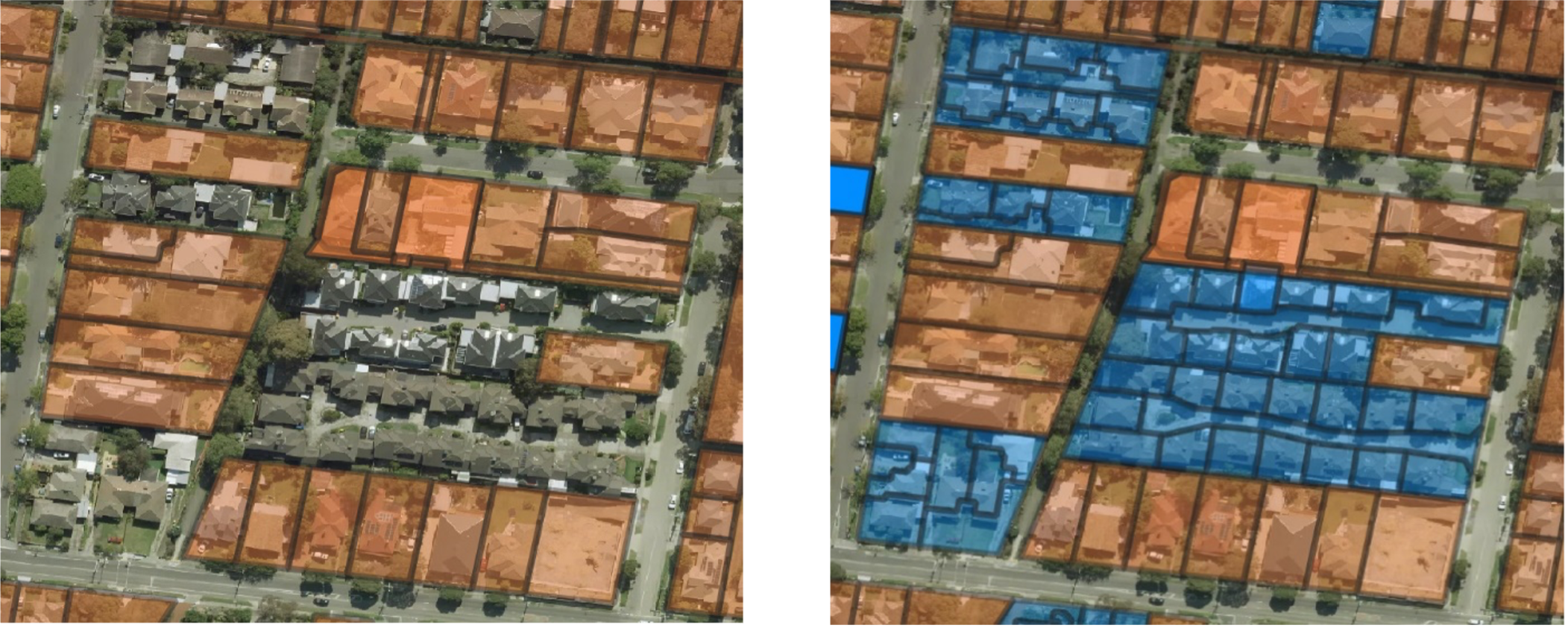
Base Parcels and how they represent a non-overlapping cadastre
Base parcels features are parcels with parcel_type of 'Lot' that have been flagged with the intention of providing a non-overlapping layer representation of cadastre parcels. A user can simply identify these records by selecting where base_parcel = 'Yes'.
Below, the two images show the cadastre layer with no filter applied (left), as well as only where base_parcel = 'Yes' (right).
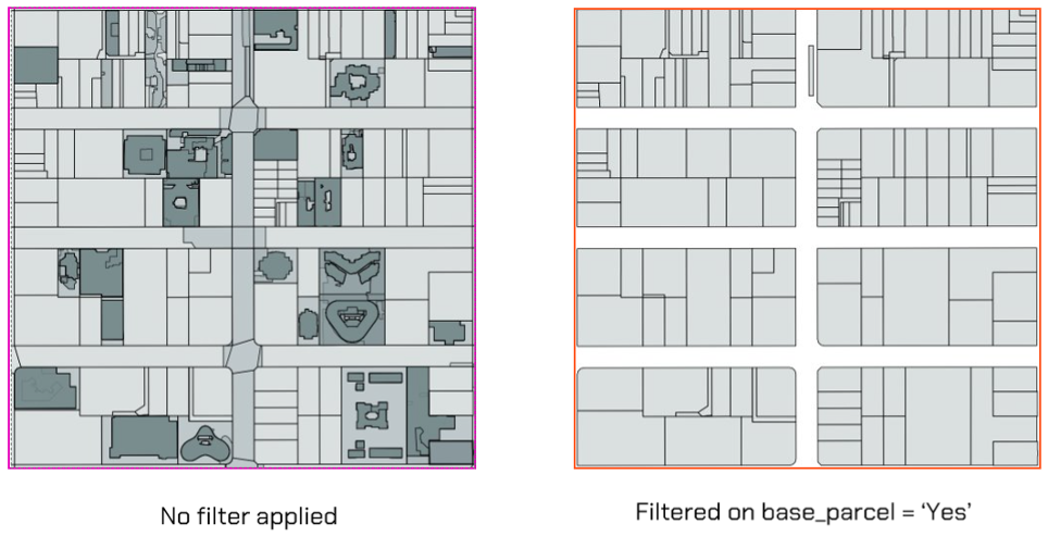
The designation of a base parcel, and the creation of 'Geoscape Australia' source base parcels, was important so that a simple and complete coverage polygon layer could be provided for visualization and analytics, as well as allowing strata counts to be assigned consistently to Lot parcels across each State and Territory. To the right, the base parcels are shown (orange polygons) with total_strata_count labels (white text).
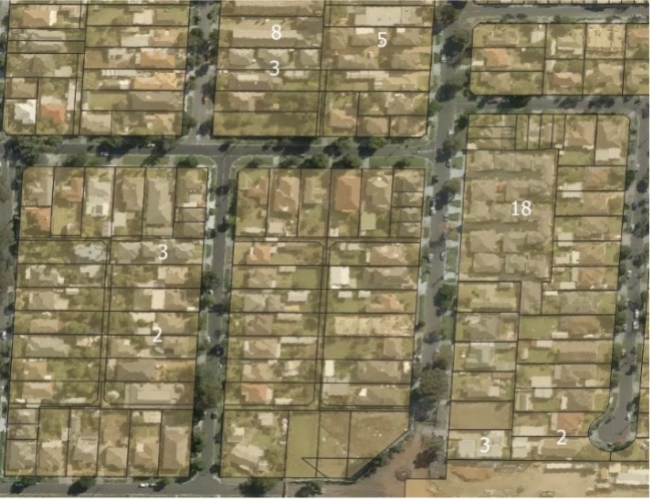
Base Parcels with total_strata_counts (white text) shown with © Aerometrex Ltd Aerial Imagery [Aerometrex, 2023].
Only parcels with a Parcel Type of ‘Lot’ that are not contained by another Lot parcel can be part of the base representation. There are a small percentage of cases where there are Lot parcels that overlap but do not contain each other. In these scenarios, each of the overlapping Lot parcels are assigned as base parcels to retain coverage and avoid gaps in the base layer. Below an example of this is shown in NT where the yellow Lot parcel overlaps the blue Lot parcel and both are assigned as base parcels for coverage in the base layer.
Using ‘Geoscape Australia’ source parcels
Parcels with a Source value of 'Geoscape Australia' have been created to add a Lot parcel representation for sites where one is not provided by the jurisdiction. This was done so that a Lot parcel representation could be added, contributing to the continuous, non-overlapping representation of cadastre lots.
They are generated using related Strata or Stratum parcels that are supplied by the jurisdiction to create the best representation of a Lot parcel for the site.
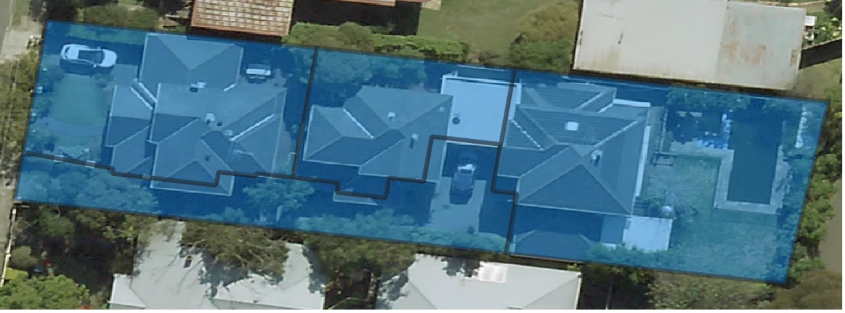
Example
Victoria: 145.0390311, -37.7665132
Below images show the Lot parcels provided by the jurisdiction in Victoria as orange polygons. These will have a Source attribute value of ‘VIC’.
On the left you can see that when only Lot parcels are visible there are “gaps” or “missing” polygons over some parcels of land. In Victoria, these gaps are covered by Strata parcels, shown in blue on the right.
Example of Lot parcel (left) and Strata parcel (right) coverage in VIC shown with © Aerometrex Ltd Aerial Imagery [Aerometrex, 2023].
A 'Geoscape Australia' source parcel (green polygon below, bottom) was created here based on a dissolve of these strata parcels (blue polygons below, top). Example located at 145.0385614, -37.7665431.
Strata parcels shown with © Aerometrex Ltd Aerial Imagery [Aerometrex, 2023].
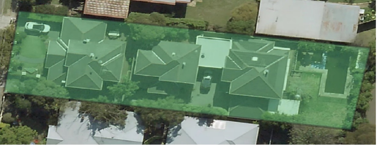
Geoscape Australia Lot parcel created by dissolving the Strata parcels © Aerometrex Ltd Aerial Imagery [Aerometrex, 2023].
This created Geoscape Australia parcel is a 'Lot' parcel_type parcel that will have a base_parcel value of 'Yes'.
This parcel will also have strata counts assigned, as it has strata parcels relating to it. At this site, three non-common property strata parcels are related to the Geoscape Australia parcel so the horizontal_strata_count and total_strata_count will be '3'.
The parcel_id for Geoscape Australia records will not be searchable in the State or Territory land registry as the parcel has not been provided by the jurisdiction.
In the below image, base_parcel = 'Yes' parcels are turned on (pink polygons). The image shows that there is base Lot coverage across both sites where the jurisdiction provides Lot parcels (source = 'VIC') and where Lot parcels have been created (source = 'Geoscape Australia'). This provides a consistent base layer and allows strata counts to be applied to the base layer.
Base parcels shown with © Aerometrex Ltd Aerial Imagery [Aerometrex, 2023].
Linking CadLite to National Cadastre
A linkage table has been included to facilitate the transition between the CadLite Cadastre theme and the new National Cadastre product. This table enables the link between the Cad_Point and Cad_Polygon features in CadLite to their corresponding Cadastre feature where possible.
The link was created by matching the CadLite jurisdiction_id with the National Cadastre parcel_id, supported by a spatial comparison where there was more than one match resulting from the join.
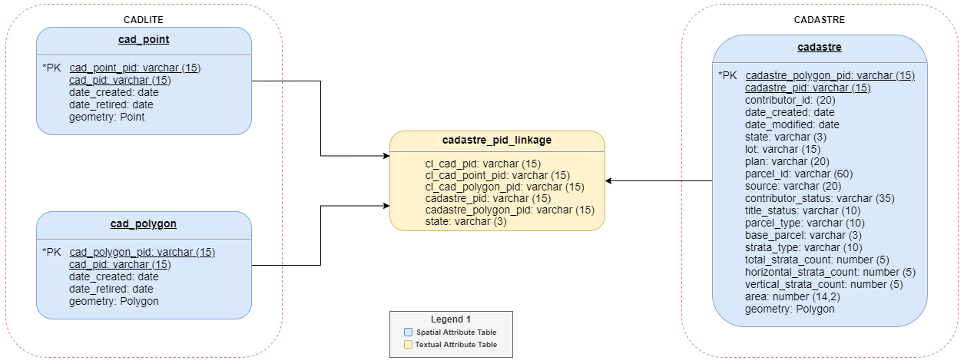
If a parcel does not have a record in the linkage table, a link between CadLite and National Cadastre could not be created. This occurred where:
There was no match between the CadLite jurisdiction_id and a National Cadastre parcel_id. This may happen if:
the feature is no longer represented in National Cadastre (e.g. easements),
the CadLite jurisdiction_id no longer exists,
the National Cadastre parcel_id is new, or
the values could not confidently be joined during the linking process
There were multiple matches between a CadLite jurisdiction_id and a National Cadastre parcel_id and:
the spatial check did not support the join, or
the spatial check could not identify a one-to-one link
The source attribute has a value of ‘Geoscape Australia’ in National Cadastre