Technical Description
National Property is created through processing property data sourced from Australia’s States and Territories. Source attributes are mapped and standardised to provide a coherent definition across the jurisdictional supplies, with associated geometry being cleaned and processed to output a topologically consistent layer of Australia’s property boundaries at a national scale.
Each property record has a boundary representing the overall coverage of the single property and a Contributor ID which is the jurisdiction’s reference to the property for land valuation and other property purposes. The Contributor ID can be utilised for searches in the relevant jurisdiction’s land valuation system to provide the indicative value of the property for rating purposes.
National Property is updated and released regularly and has integrated relationships with other Geoscape Products. Further information regarding attributes, quality, coverage and product release details are outlined below.
Linkages
National Property is integrated with the following Geoscape products:
National Cadastre
G-NAF
Buildings
The joins used to link to these products are shown below, with attributes used in the joins described.
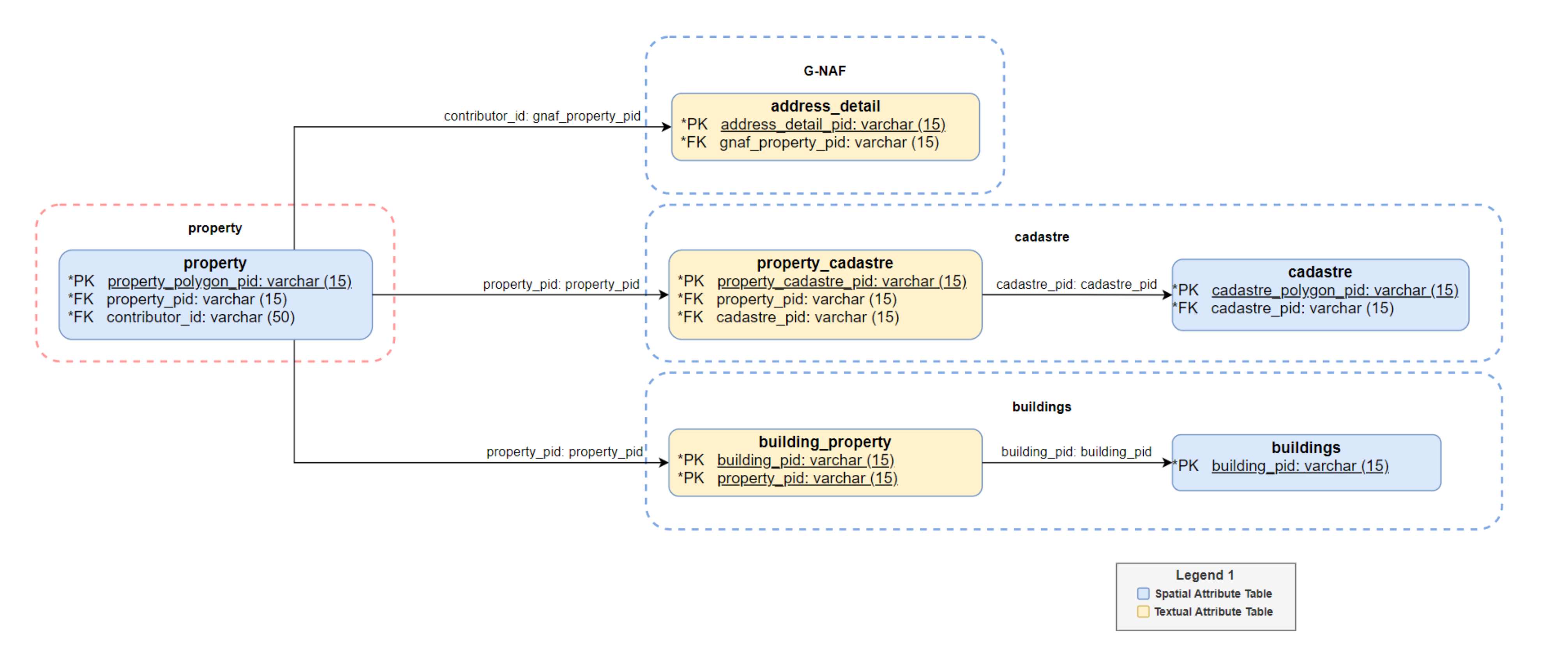
The property_pid attribute can be used to link to a cadastre_pid in the National Cadastre product where a relationship between National Property and National Cadastre exists. These relationships are represented within the property_cadastre table within the National Property product. The three possible relationships between National Cadastre and National Property are:
one cadastral parcel is equal to one property
many cadastral parcels make up one property
one cadastral parcel contains many properties
Attributes
Contributor ID
The Contributor ID is the property identifier provided by the jurisdiction that is searchable for land valuation and rates purposes. The associated attribute(s) in the jurisdiction source data for each State or Territory are found in the table below.
State |
Jurisdiction Value |
|---|---|
ACT |
TITLE_NUMBER [1] |
BLOCK + “/” + SECTION + “/” + DIVISION_CODE [2] |
|
NSW |
PROPID |
NT |
VOLUME_TYP + “/” + VOLUME_NO + “/” + FOLIO_NO |
QLD |
PROPERTY_ID |
SA |
ASSNO_TENSEQNO |
TAS |
PID |
VIC |
PFI |
WA |
VPU_VE_NUMBER |
Source
The name of the State or Territory that the property data was sourced from.
Base Property
The Base Property allows for a simple visualisation of property coverage across all States and Territories without overlapping parcels. Only property parcels which are not contained by another property can be part of the base representation.
Area
The area of each property polygon in square meters, calculated from the feature geometry using an equal area projection. The total area in square meters can be calculated by summing property parcels with a common National Property PID.
Data Model
![digraph G {
fontname="ROBOTO" fontsize="10pt"
node [fontname="ROBOTO" fontsize="8pt"]
edge [fontname="ROBOTO" fontsize="8pt"]
rankdir=LR
graph [pad="0.5", ranksep="1"];
subgraph cluster_property { label="National Property"
graph[style="dashed,rounded" color="#EA6B66"]
property [shape=plain
label=<<TABLE BGCOLOR="#7EA6E0"
BORDER="1"
CELLBORDER="0"
style="rounded"
CELLSPACING="0"
CELLPADDING="5">
<TR>
<TD COLSPAN="2">property</TD>
</TR>
<TR>
<TD BGCOLOR="white" >PK</TD>
<TD BGCOLOR="white" ALIGN="LEFT" >property_polygon_pid: varchar (15) </TD>
</TR>
<TR>
<TD BGCOLOR="white" >FK</TD>
<TD BGCOLOR="white" ALIGN="LEFT" >property_pid: varchar (15) </TD>
</TR>
<TR>
<TD BGCOLOR="white" ></TD>
<TD BGCOLOR="white" ALIGN="LEFT" >contributor_id: varchar (50) </TD>
</TR>
<TR>
<TD BGCOLOR="white" ></TD>
<TD BGCOLOR="white" ALIGN="LEFT" >date_created: date </TD>
</TR>
<TR>
<TD BGCOLOR="white" ></TD>
<TD BGCOLOR="white" ALIGN="LEFT" >date_modified: date </TD>
</TR>
<TR>
<TD BGCOLOR="white" ></TD>
<TD BGCOLOR="white" ALIGN="LEFT" >state: varchar (3) </TD>
</TR>
<TR>
<TD BGCOLOR="white" ></TD>
<TD BGCOLOR="white" ALIGN="LEFT" >source: varchar (20) </TD>
</TR>
<TR>
<TD BGCOLOR="white" ></TD>
<TD BGCOLOR="white" ALIGN="LEFT" >base_property: varchar (3) </TD>
</TR>
<TR>
<TD BGCOLOR="white" ></TD>
<TD BGCOLOR="white" ALIGN="LEFT" >area: number (14,2) </TD>
</TR>
<TR>
<TD BGCOLOR="white" ></TD>
<TD BGCOLOR="white" ALIGN="LEFT" >geometry: Polygon </TD>
</TR>
</TABLE>>];
property_cadastre [shape=plain
label=<<TABLE BGCOLOR="#FFD966"
BORDER="1"
CELLBORDER="0"
style="rounded"
CELLSPACING="0"
CELLPADDING="5">
<TR>
<TD COLSPAN="2">property_cadastre</TD>
</TR>
<TR>
<TD BGCOLOR="white" >PK</TD>
<TD BGCOLOR="white" ALIGN="LEFT" >property_cadastre_pid: varchar (15) </TD>
</TR>
<TR>
<TD BGCOLOR="white" ></TD>
<TD BGCOLOR="white" ALIGN="LEFT" >date_created: date </TD>
</TR>
<TR>
<TD BGCOLOR="white" >FK</TD>
<TD BGCOLOR="white" ALIGN="LEFT" >property_pid: varchar (15) </TD>
</TR>
<TR>
<TD BGCOLOR="white" >FK</TD>
<TD BGCOLOR="white" ALIGN="LEFT" >cadastre_pid: varchar (15) </TD>
</TR>
</TABLE>>];
}
property -> property_cadastre [arrowhead=crownoneodot dir=both arrowtail=crownoneodot]
subgraph cluster_legend {
graph[style="" label="Legend" ]
legend [shape=plain
label=<<TABLE
CELLBORDER="0"
Border="0">
<TR>
<TD BGCOLOR="#7EA6E0" BORDER="1"> </TD>
<TD>Spatial Attribute Table</TD>
</TR>
<TR>
<TD BGCOLOR="#FFD966" BORDER="1"> </TD>
<TD>Textual Attribute Table</TD>
</TR>
</TABLE>>]
key [shape=plain label=<<table border="0" cellpadding="1" cellspacing="0" cellborder="0">
<tr><td port="i1"> Zero or Many </td> </tr>
</table>>]
key2 [shape=plain label=<<TABLE border="0" cellpadding="1" cellspacing="0" CELLBORDER="0">
<tr><td port="i1"> </td></tr>
</TABLE>>]
key:i1 -> key2:i1 [arrowhead=crownoneodot]
}
}](_images/graphviz-079467167bafe057df99260e8c667b1b648b6e43.png)
Data Dictionary
Attribute |
Data Type |
Description |
Primary Key |
Mandatory |
10 Character Alias |
|---|---|---|---|---|---|
property_polygon_pid |
Character String (15) |
Persistent identifier for each property polygon. |
Yes |
Yes |
PR_PLY_PID |
property_pid |
Character String (15) |
Persistent Identifier for the property feature for the life of the property. |
No |
Yes |
PR_PID |
contributor_id |
Character String (50) |
An identifier used to link back to the contributor data where the contributor supplies a persistent identifier. |
No |
Yes |
CNTRB_ID |
date_created |
Date |
The date the record is first introduced to the Geoscape product. |
No |
Yes |
DT_CREATE |
date_modified |
Date |
The latest date that this record has been modified. |
No |
No |
DT_MOD |
state |
Character String (3) |
The abbreviated name of the State or Territory that the property spatially resides within. |
No |
Yes |
STATE |
source |
Character String (20) |
The State or Territory authority that has provided the source data for the property. |
No |
Yes |
SOURCE |
base_property |
Character String (3) |
A ‘Yes’ flag indicates that the parcel is part of the base representation. |
No |
No |
BASE_PROP |
area |
Number (14,2) |
The area in square metres of the polygon. |
No |
Yes |
AREA |
geometry |
Polygon |
The geometry of the polygon. |
No |
Yes |
GEOMETRY |
Attribute |
Data Type |
Description |
Primary Key |
Mandatory |
10 Character Alias |
|---|---|---|---|---|---|
property_cadastre_pid |
Character String (15) |
Persistent identifier for each property_cadastre record. |
Yes |
Yes |
PR_CAD_PID |
date_created |
Date |
The date the record is first introduced to the Geoscape product. |
No |
Yes |
DT_CREATE |
property_pid |
Character String (15) |
Persistent Identifier for the property feature for the linked property record. |
No |
Yes |
PR_PID |
cadastre_pid |
Character String (15) |
Persistent Identifier for the cadastre feature for the linked cadastre record. |
No |
Yes |
CAD_PID |
Domain Values
state
Domain Value |
Description |
|---|---|
ACT |
The data is located within the Australian Capital Territory. |
NSW |
The data is located within the state of New South Wales. |
NT |
The data is located within the Northern Territory. |
OT |
The data is located within the Other Territories classification. Other Territories covers the external Australian territories of Cocos (Keeling) Islands, Christmas Island, Jervis Bay and Norfolk Island. |
QLD |
The data is located within the state of Queensland. |
SA |
The data is located within the state of South Australia. |
TAS |
The data is located within the state of Tasmania. |
VIC |
The data is located within the state of Victoria. |
WA |
The data is located within the state of Western Australia. |
source
Domain Value |
Description |
|---|---|
ACT |
The source data for the record was provided by the Australian Capital Territory Government. Jervis Bay data is sourced from the Australian Capital Territory Government. |
NSW |
The source data for the record was provided by the New South Wales Government. |
NT |
The source data for the record was provided by the Northern Territory Government. |
Norfolk Island |
The source data for the record was provided by the external Australian territory of Norfolk Island. |
QLD |
The source data for the record was provided by the Queensland Government. |
SA |
The source data for the record was provided by the South Australian Government. |
TAS |
The source data for the record was provided by the Tasmanian Government. |
VIC |
The source data for the record was provided by the Victorian Government. |
WA |
The source data for the record was provided by the Western Australian Government. Cocos (Keeling) Islands and Christmas Island data is sourced from the Western Australian Government. |
Geoscape Australia |
The data has been created by Geoscape for the purposes of base parcel coverage. |
base_property
Domain Value |
Description |
|---|---|
Yes |
The property polygon has been identified as a base property. A base property is not contained by any other property parcel and provides base coverage across each state and territory. |
<NULL> |
The property parcel has been identified as not being a base property. Property parcels contained by other property parcels will have <NULL> values for this field. |
Update Frequency
National Property is continuously updated and released with the most up to date data available on a monthly schedule.
Data Quality
Positional Accuracy
National Property has been created by combining land valuation/rates information with National Cadastre. To achieve a single property representation a union of multiple National Cadastre boundaries happens during production. This will preserve the outer boundaries accuracies as supplied by the jurisdiction. Geoscape makes minor changes only where they are required to create valid features described in National Property Geometry Validity.
Coordinates Referencing the GDA2020 Datum
Spatial features referencing the GDA2020 datum are produced using a coordinate transformation from the GDA94 datum using the following parameters.
shift_x = 0.06155,shift_y = -0.01087,shift_z = -0.04019,rotate_x = -0.0394924,rotate_y = -0.0327221,rotate_z = -0.0328979,scale_adjust = -0.009994
National Property Geometry Validity
National Property geometry is validated to ensure polygons are a valid representation and free of self-intersection. Issues being detected and resolved include spikes, bow ties, duplicate vertices, null geometries, multipart geometries, and self-contacts. Minor overlaps are also resolved where a property has a Base Property of ‘Yes’. Overlapping polygons will persist in the product as they can be valid geometries representing the jurisdictions intent.
Polygon orientation conforms to the following specifications:
OGC Simple Feature Access Specification v1.2.1 [Section - 6.1.11.1]
The GeoJSON Specification RFC7946 [Section 3.1.6 dot point 4]
This means the polygon outer boundary will be counter clockwise and the inner boundary will be clockwise for file formats that support the above standards.
Further Comments
National Property has been processed to assure all polygons are stored as single part features to improve capability with a range of software applications. Due to this there is duplication of the National Property PID and Contributor ID information.
Extent/Geographic Description
The spatial coverage of National Property includes Australia’s land mass and surrounding offshore islands.
The Bounding Box for this data is as follows:
North bounding latitude: -8˚
South bounding latitude: -45˚
East bounding longitude: 155˚
West bounding longitude: 112˚
A detailed description of the coverage for each State and Territory is provided in the table below.
State |
Specific Area |
Coverage |
|---|---|---|
ACT |
Complete coverage. |
|
NSW |
Complete coverage. |
|
NT |
Complete coverage. |
|
OT |
Christmas and Cocos (Keeling) Islands |
Complete coverage. |
Jervis Bay |
Complete coverage. |
|
Norfolk Island |
Complete coverage. |
|
QLD |
Complete coverage [3]. |
|
SA |
Complete coverage. |
|
TAS |
Complete coverage. |
|
VIC |
Complete coverage. |
|
WA |
Complete coverage. |
Spatial Reference System
GDA94
Horizontal Datum: The Geocentric Datum of Australia 1994 (GDA94) is the target horizontal datum.
Coordinate System: Geographic Coordinate System Geocentric Datum of Australia 1994 (GDA94).
GDA2020
Horizontal Datum: The Geocentric Datum of Australia 2020 (GDA2020) is the target horizontal datum.
Coordinate System: Geographic Coordinate System Geocentric Datum of Australia 2020 (GDA2020).
Delivery Format
National Property is provided at a National and State/Territory level, depending on the file format selected. The data is made available in the File Geodatabase, GeoJSON, ESRI Shapefile and MapInfo TAB formats described below.
Format |
National |
State/Territory |
|---|---|---|
File Geodatabase |
Yes |
Yes |
GeoJSON |
Yes |
Yes |
ESRI Shapefile |
Yes |
|
MapInfo TAB |
Yes |
File Geodatabase
GeoJSON
Note
- The GeoJSON specification states that the coordinate reference system for all GeoJSON coordinates is:
“a geographic coordinate reference system, using the World Geodetic System 1984 (WGS 84) datum, with longitude and latitude units of decimal degrees”
National Property will be provided with coordinates using the datum selected for download (GDA94/GDA2020) with longitude and latitude units of decimal degrees.
JSON
ESRI Shapefile
MapInfo TAB
Geopackage
Product Versioning
National Property versioning is managed through incrementing when there is a change to the product schema or a significant change in data population, these are described further below:
A schema change can affect a major or minor increment to the versioning. Additive changes (changes that won’t break customers’ ability to work with the data) will be incremented with a minor version increment, an example is the addition of a new attribute. Removal of attributes or changing the structure of the National Property schema will enact a major change to identify that this requires the attention of all customers and partners.
Where a significant geography of Australia either has a new population of data for an attribute or is populated from a much higher quality source a minor increment will be applied to the product version.
Therefore, National Property versioning will not increment with every data update, published releases will have a name e.g. ‘May 2021’ and will reference a version of the National Property product e.g. ‘1.0’.