Data Capture
National Trees are a pixel representation of areas identified as having a tree coverage in remotely sensed source imagery.
National Trees are also represented as raster cells within the National Surface Cover dataset. Areas classified as trees have been integrated with Digital Surface Model (DSM) and Digital Elevation Model (DEM) Information to extract a height value for every cell.
Note
Some rasters may be empty and contain No Data. These rasters are placeholders matching the National Surface Cover dataset as a tree may have existed previously or a tree may exist in the future.
Efforts to provide an accurate height for all tree pixels have been undertaken. Due to proximity to other features, resolution and anomalies within the Digital Surface Model (DSM) and/or the Digital Elevation Model (DEM), heights for a small portion of pixels are higher than the real world feature they represent. To reduce the impact of these, all trees that are higher than plausible tree heights (100 metres) in the area are assigned a height of 25m.
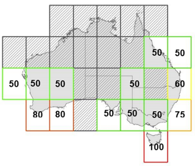
The likely maximum tree heights for each zone (region) across Australia has been determined. This has resulted in four codes listed in the below table.
Code |
Name |
Description |
|---|---|---|
50 |
Trees above 50m |
Trees pixel exceeded the expected max tree height of 50m for this region. Tree height remains unaltered. |
60 |
Trees above 60m |
Trees pixel exceeded the expected max tree height of 60m for this region. Tree height remains unaltered. |
75 |
Trees above 75m |
Trees pixel exceeded the expected max tree height of 75m for this region. Tree height remains unaltered. |
80 |
Trees above 80m |
Trees pixel exceeded the expected max tree height of 80m for this region. Tree height remains unaltered. |
The expected maximum tree heights for the zones across Australia are shown in the image below. The trees in red and hatched black regions represent areas with tree heights that are above 100m or below 25m respectively.