ABS Boundaries
ABS Boundaries provides a national representation of the Australian Statistical Geography Standard (ASGS) published by the Australian Bureau of Statistics (ABS). The product enables organisations to integrate official statistical geographies into spatial analysis, reporting, planning and decision-making workflows across Australia. It contains boundary geometries and core attributes that support demographic analysis, service planning, market analysis and statistical reporting.
The ASGS is Australia’s official framework for organising and reporting statistics geographically. Rather than being a single hierarchy, the ASGS consists of several structures designed for different analytical and reporting purposes. These structures allow users to analyse information across statistical, Indigenous, urban, remoteness and socio-economic geographies.
ABS Boundaries brings these ASGS structures together into a spatial data product, providing access to the geographic boundaries and associated attributes required to support geographic analysis and integration with other datasets.
ABS Boundaries Documents
ASGS Structures
ABS Boundaries includes the following ASGS structures:
Main Structure
The main statistical hierarchy used by the ABS for the collection and dissemination of data. This structure enables analysis at progressively larger geographic scales and includes:
Mesh Blocks (MB)
Statistical Area Level 1 (SA1)
Statistical Area Level 2 (SA2)
Statistical Area Level 3 (SA3)
Statistical Area Level 4 (SA4)
Greater Capital City Statistical Areas (GCCSA)
States and Territories (STATE)
Australia (AUS)
Indigenous Structure
Supports the publication and analysis of statistics relating to Aboriginal and Torres Strait Islander populations and communities. The structure includes:
Indigenous Locations (ILOC)
Indigenous Areas (IARE)
Indigenous Regions (IREG)
Urban Structure
Represents Australia’s towns, cities and urban population centres and includes:
Urban Centres and Localities (UCL)
Sections of State (SOS)
Section of State Ranges (SOSR)
Significant Urban Areas (SUA)
Remoteness Structure
Provides a nationally consistent classification describing relative access to services and population centres across Australia. This structure supports analysis of regional and remote communities.
Socio-Economic Structure
Socio-Economic Indexes for Areas (SEIFA) provide measures of relative socio-economic advantage and disadvantage and can be used to support demographic, social and economic analysis.
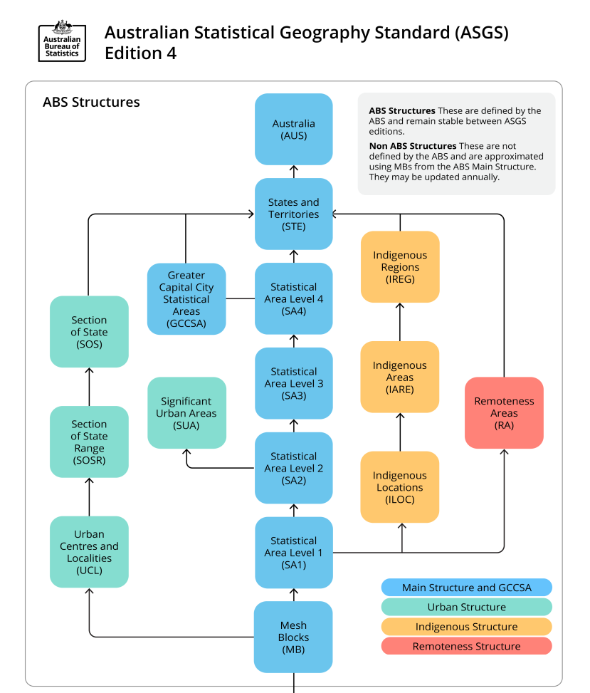
2026 ASGS ABS Structures, extracted from the ABS Geography Website ABS Geography Website
Coverage
ABS Boundaries provides national coverage for Australia, including states, territories and recognised external territories. The dataset aligns with the current ASGS framework published by the Australian Bureau of Statistics and is maintained to support a broad range of statistical and spatial analysis applications.